Page 1 of 1
British Isles map error

Posted:
Wed Apr 19, 2006 4:57 amby max is gr8
you can attack from Northumberland to borders which is very annoying in game
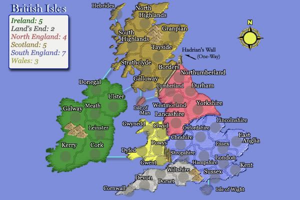
http://www.conquerclub.com/game.php?game=12709#gmtop As you can see my ally had scotlands bonus and lost it because of this error.
Posted:
Wed Apr 19, 2006 5:15 amby Nobunaga
... Of course you can attack Borders from N'umberland. It's Hadrian's Wall.
... Cumberland can attack Galloway as well.
Posted:
Wed Apr 19, 2006 5:17 amby max is gr8
In the key can you at least put one way attack.
Posted:
Wed Apr 19, 2006 5:23 amby Nobunaga
... The arrow above the word "Hadrian's Wall" is meant to indicate a one-way attack. The Large map is even more clear.
Posted:
Wed Apr 19, 2006 5:23 amby Axelius
I guess the map maker thought people would understand the arrow above it as "one way attack"
Posted:
Wed Apr 19, 2006 5:26 amby Nobunaga
... Indeed he
probably did.

... That, and the history of the Roman Empire in the British Isles.
Posted:
Wed Apr 19, 2006 5:32 amby Nobunaga
... I shouldn't get all snarky, though. Apologies. I'll edit the map (both large and small) to make it very clear that it's a set of one-way borders along the wall.
... Not today, but in a few days to be sure.
Posted:
Wed Apr 19, 2006 7:28 amby wicked
It's pretty obvious to those of us who can read.
Posted:
Wed Apr 19, 2006 8:16 amby thegrimsleeper
Nobu, please tell me you're not going to edit your map because MAX has a problem understanding it?!
Posted:
Wed Apr 19, 2006 8:21 amby Nobunaga
... Actually, Grim, I've had a few complaints from other folks as well.
... I've already edited the thing - just put the words, "One Way" by the arrow. Lack will no doubt put it up when he has the time.
... The large map was already so labeled, but a lot of folks don't look at the big maps - gotta scroll.
Posted:
Wed Apr 19, 2006 9:10 amby Fieryo
i was fooled by the one way thing a few times myself, but if there can be a "bug" in the Europe map why cant there be a one way route in the British map that even has an arrow? I say leave it and let people learn the hard way.

Posted:
Wed Apr 19, 2006 10:24 amby zorba_ca
Hi Nobu:
Seeing as you are updating the British Isles map (which I really enjoy, by the way), one more suggestion.
Isle of Man looks to be brown in colour (meaning it would be part of Scotland). Only after an opponent missed out on a bonus did I realize that it is actually pink in colour (and therefore part of North England).
I guess that this discrepancy in the shading is due to the colour of the circle in which the # of armies is located, and because this circle covers the entire territory (because it is so small).
I was wondering if you could either eliminate the shading that is present for that territory, or move the # of armies just off to the side of the territory to allow the true colour to show through.
Thanks.
Posted:
Thu Apr 20, 2006 5:51 amby Nobunaga
... I took away the shading in a test run, and it just looks absurdly pink...
... Here it is with the "note", for the historically handicapped.
Posted:
Thu Apr 20, 2006 9:10 amby zorba_ca
To me it still looks too similar to Scotland. Could you shift the shaded circle a bit to one side?
Posted:
Thu Apr 20, 2006 9:15 amby Marvaddin
Man, your map is really a good one. I love it. But I want do 2 little complaints:
1st: I really cant saw the Isle of Wight... If its borders would be a bit darker, maybe it would be better visible. Now, we know its there, but we cant see it.
2nd: Isle of Man seems to be connected to Hadrian's Wall, not Cumberland. Maybe changing the route to Westmorland...
Thanks for the great map!!
Posted:
Tue Apr 25, 2006 11:11 amby grazza
Nobunaga
Great map.
Just one query - what's the markings between Gwent and Shropshire - are they meant to indicate a barrier, or is it a standard boundary - has confused me!
Grazza
Posted:
Tue Apr 25, 2006 11:30 amby Jota
I believe those are trees, forming an uncrossable border.