World 2.0/1 Map [Quenched]
Moderator: Cartographers
![]() by sully800 on Sat Sep 23, 2006 7:26 pm
by sully800 on Sat Sep 23, 2006 7:26 pm
Yeah I agree. I'm thinking like different shades of each color for the subcontinent. So US+Canada could be dark purple and Central America+Carribean would be light purple, but that is all of the purple on the map. Then do that for each continent and sub continent. So NA is shades of purple, SA is brows, Africa reds, Europe greens, Asia blues and Australia yellows. The only problem you might run into is if a sub continent has countries from different main continents (Middle East would contain some Asia, Europe and Africa). I think that problem can be solved be simply keeping the subcontinents as pieces of the main continents. It may not be as fun for gameplay, but I don't know how else you would show whcih countries group together to form the various regions.
-

 sully800
- Posts: 4978
- Joined: Wed Jun 14, 2006 5:45 pm
- Location: Bethlehem, Pennsylvania


![]() by happysadfun on Sat Sep 23, 2006 7:27 pm
by happysadfun on Sat Sep 23, 2006 7:27 pm
Pakistan+Afghanistan=Muslim India
Brazil+Uruguay=Portuguese South America or just Brazil
Not all of French Africa is French.
The East-West stuff in North America is annoying. New England. Colonial Canada. Frontier Canada. American Bayou. There's great names you are ignoring. And the midwest doesn't go that far west. And the straight lines are killing me. Can't you find a river somewhere?
But I like the map
 Children, this is what happens to hockey players, druggies, and Hillary Clinton.
Rope. Tree. Hillary. Some assembly required.
-

happysadfun
- Posts: 1251
- Joined: Mon Jul 10, 2006 9:06 pm
- Location: Haundin at DotSco, Being Sad that Mark Green Lost in Suburban Wisconsin
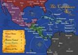 MIDDLE AMERICA MAP

![]() by cowshrptrn on Sat Sep 23, 2006 9:41 pm
by cowshrptrn on Sat Sep 23, 2006 9:41 pm
jsut combine pakistan and Afganistan into pakistan, they had a puppet gov. in afganistan for a while b4 9/11 anyway.

-

cowshrptrn
- Posts: 838
- Joined: Thu Aug 17, 2006 1:15 pm
- Location: wouldn't YOU like to know....

Sub territories....
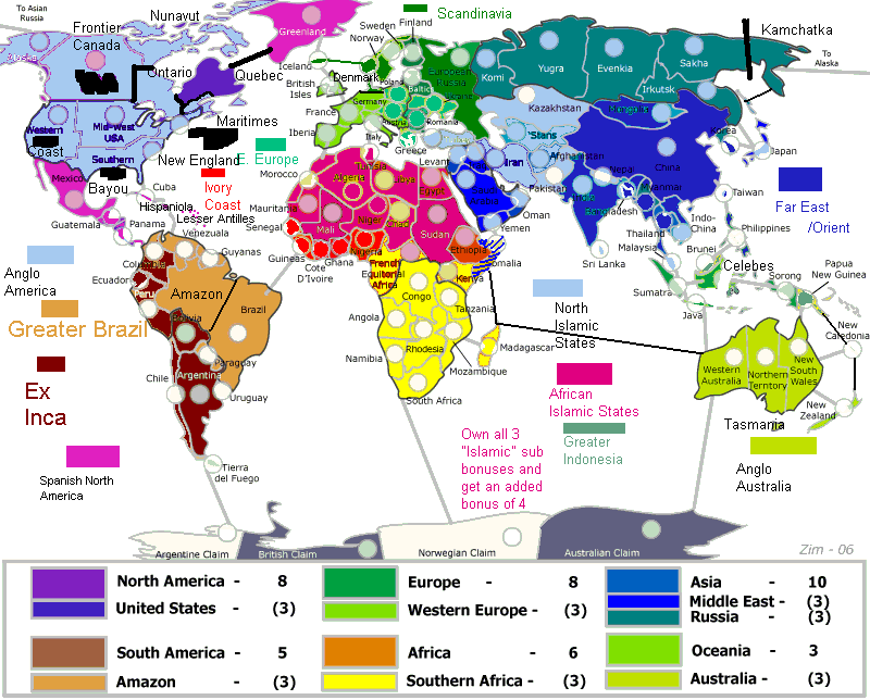
![]() by zim on Mon Sep 25, 2006 4:39 pm
by zim on Mon Sep 25, 2006 4:39 pm

Please ignore the legend in the above I haven't updated the image to reflect my re-calculations of sub-bonus and continent values.
Happysadfun wrote:
The East-West stuff in North America is annoying. New England. Colonial Canada. Frontier Canada. American Bayou. There's great names you are ignoring. And the midwest doesn't go that far west. And the straight lines are killing me. Can't you find a river somewhere?
I agree the straight lines didn't look right. I've updated Canada and Australia using provincial/state boundries as a guide instead. Thanks for the nudge.
Sully800 wrote:
Yeah I agree. I'm thinking like different shades of each color for the subcontinent. So US+Canada could be dark purple and Central America+Carribean would be light purple, but that is all of the purple on the map. Then do that for each continent and sub continent. So NA is shades of purple, SA is brows, Africa reds, Europe greens, Asia blues and Australia yellows. The only problem you might run into is if a sub continent has countries from different main continents (Middle East would contain some Asia, Europe and Africa). I think that problem can be solved be simply keeping the subcontinents as pieces of the main continents. It may not be as fun for gameplay, but I don't know how else you would show whcih countries group together to form the various regions.
and Evil Pope wrote:
Maybe the colors of the countries could be more uniform in the parts that are sub continents.. For example, if you were to separate US and canada, and mexico and guatemala(and the rest).. The US and canada could be one of the shades(maybe the darker blue) and then Mexico and guatemala(and the rest) could be another shade being used in north america, like the pinkish color.. That way they continents are more uniform, but you can differentiate between the subcontinents..
I've attempted this in the version above using a uniform colour for the sub-continents but still using various colours (in the same family) for the rest of the continent. I think the colour difference's make the boundries clearer but they do also make it 'louder' so I can see both sides. Let me know what you think of the current version. I also agree the single territory in multiple sub-continents is strategically interesting (though it might turn out to be just a gimmick) but practically difficult and a source of confusion for those new to the map. The current implementation of sub-continents doesn't contain any "multiple" territories.
Marvaddin wrote (and drew):
Maybe the colors of the countries could be more uniform in the parts that are sub continents.. For example, if you were to separate US and canada, and mexico and guatemala(and the rest).. The US and canada could be one of the shades(maybe the darker blue) and then Mexico and guatemala(and the rest) could be another shade being used in north america, like the pinkish color.. That way they continents are more uniform, but you can differentiate between the subcontinents..
and Scorba wrote:
Great to hear your considering the sub-bonus regions. My enthusiam for the map has increased a hundred fold.
With Europe, I'd recommend a three way split, with Scandinavia, Western (Italy, Germany and everything west) & Eastern (everything else).
Asia - from a strategic point of view it makes little difference whether Egypt is included in the Middle East, but it is a big political player in the region so it makes sense from that perspective. Other Asian regions could include The Orient (or South Eastern Asia) & the Indian Sub-Continent. With the Asian Russia split, it would be good to split it so that at least one territory is not a border.
North America - perhaps Central America including Cuba & the Carribean? It might be an idea to have Canada & the US combined into a single region. The US would be unholdable without first having Canada anyway, and Canada as a two country region would be too easy to take..
South America - I think Brazil needs to be split up and form another region. It currently dominates the continent, attacking nearly every other country and Africa as well. It can also hit NA in two moves. It's probably the most powerful country on the map as it stands, and certainly will be once Russia is further divided. If you decided to go down this route, I'm sure Marv could help with naming the territories.
Oceania - Perhaps include New Zealand and New Caledonia in with the Aus region? The other islands could form another region, though no idea what you'd call it.
Africa - I haven't got any ideas here. The Wikipedia page you posted looks like a good start though.
I was going to attempt to implement a hybrid of your respective suggestions and actually began colouring the map accordingly. Anyway inspiration (or insanity) struck when I was doing the split of Russia and I thought why does every territory need to be part of a sub-continent. Could we not pick out selected parts of a continent and make them a bonus without having an equivalent bonus for every territory? This is the approach I've taken in the version above. I'm intrigued with it but I'm looking for feedback. My intial bonus/sub-bonus thinking would look something like:
North America(United States) 6(2)
South America(Amazon) 6(2)
Africa(Southern Africa) 12(7)
Europe(Western Europe) 8(3)
Asia(Middle East/Russia) 14(3/5)
Oceania(Australia) 5(3)
As with the previous bonus discussion these could be discounted preserving proportionality as best as possible if the consensus is they are two large.
GavinSidhu wrote:
I think what you want to do is not get the map to look like the classic one. Splitting Australia in half and now your suggesting ur going to split asian russia is doing exactly that, making this map look more classic. Have you thought about my other suggestion, adding maldives as a link between Sri Lanka, Australia and Africa?
I very much don't want to recreate classic. What do you think now that you can see Australia and Russia broken up and Antarctica added?
Thanks everyone for your suggestions and sorry if I missed anyone's input. Let me know what you think particularly on the "only selected countries are members of a bonus area" idea.
Cheers,
Mark
P.S. The circles are still a touch small at 15x15 so we probably need to lose a couple more in africa and maybe one or two of the smaller asian states (nepal?).
P.P.S. What do you all think of Oceania now that Australia is split? Should I consolidate Indonesia or leave it making Oceania a more 'average' size in terms of territories?
P.P.P.S. Noticed in reviewing this post that it isn't clear that northern Canada was intended to be part of the Eastern Canada territory. Looking at it seems we have two options; 1) recolour/move the dot/name, etc., so that it's membership as part of the East is clear. 2) promote it to it to be another territory "Nunanvut". What say you?
-

zim
- Posts: 180
- Joined: Thu Jul 27, 2006 4:55 pm


![]() by happysadfun on Mon Sep 25, 2006 5:40 pm
by happysadfun on Mon Sep 25, 2006 5:40 pm
I say make it its own territory, Nunavut. And to make an even bigger subbonus- use "anglo-america": all of the us and canada, possibly making quebec separate and not including it. this would make three territories: quebec, maritimes, ontario. instead of an australia subbonus, what about an indonesia subbonus? madagascascar is in southern africa too. middle east also includes egypt, maybe make egypt an overlap country. differentiate sub-bonus colours more. i like the new version better. and i like the way this is turning out. (Originally I thought it would be a quick passing idea.)
Children, this is what happens to hockey players, druggies, and Hillary Clinton.
Rope. Tree. Hillary. Some assembly required.
-
happysadfun
- Posts: 1251
- Joined: Mon Jul 10, 2006 9:06 pm
- Location: Haundin at DotSco, Being Sad that Mark Green Lost in Suburban Wisconsin
![]() by gavin_sidhu on Mon Sep 25, 2006 8:02 pm
by gavin_sidhu on Mon Sep 25, 2006 8:02 pm
If you are going to get rid of Nepal, split up China to create Tibet. Link New Zealand to New Caledonia. Isnt Sorong really Irian Jaya? The territory you call Northern Territory in Australia is actually comprised of South Australia and the Northern Territory and looking at the picture, the name Northern Territory doesnt really fit. Maybe you should split your 'Northern Territory' into the real Northern Territory and South Australia. Antartica should wrap around.
Highest Score: 1843 Ranking (Australians): 3
-

gavin_sidhu
- Posts: 1428
- Joined: Mon May 22, 2006 6:16 am
- Location: Brisbane, Australia
![]() by happysadfun on Mon Sep 25, 2006 8:36 pm
by happysadfun on Mon Sep 25, 2006 8:36 pm
Borneo= Sulawesi and Borneo
Austria, Germany, Poland Not Western
Germany=Germany, Denmark (expanded)
SubBonus-Northern Muslim Countries=Kazakh, Stans, Iran, Afghanistan, Pakistan
Somalia=Overlap Arab Asia/Africa
Or you could use Greater Arab World in Africa and Asia as a giant subbonus including Mideast, North Muslim States, Algeria, Egypt, Somalia, Libya, Tunisia, Morocco, Mauritania, Sudan
Children, this is what happens to hockey players, druggies, and Hillary Clinton.
Rope. Tree. Hillary. Some assembly required.
-
happysadfun
- Posts: 1251
- Joined: Mon Jul 10, 2006 9:06 pm
- Location: Haundin at DotSco, Being Sad that Mark Green Lost in Suburban Wisconsin


![]() by GabonX on Tue Sep 26, 2006 12:48 am
by GabonX on Tue Sep 26, 2006 12:48 am
I don't know if somebody said this, but I think it would be cool if the countries had bonuses where their is heavy industry in the real world. Let me explain...On the Canada map you get + 1 for holding downtown. I think it would be cool if you got + a certain amount of armies for holding countries like China for industry, the Northeast United States for industry, some middle Eastern countries for oil etc. It could be the theme of this map, and it looks like this one could be big enough to pull it off.
-

GabonX
- Posts: 899
- Joined: Sat Jul 08, 2006 10:38 am


![]() by Scorba on Tue Sep 26, 2006 12:50 am
by Scorba on Tue Sep 26, 2006 12:50 am
I would like to see at least two sub-regions in each continent (three in Asia and Africa), as it would create local competition amongst players. Currently none of the regions border each other which just turns half the map in to No Mans Lands, where there is little incentive to conquer the area. What you will see is players just maintaining a presence there to stop others taking the larger continent bonus. They'll be little or none of the pressure created by having an opponents defensive stack bordering your own continent.
It will make for a much more interesting game for the majority of countries to be part of a region. The scope for diplomacy, which I feel is too unbalancing on the smaller maps, would also be greatly increased.
I agree that Nunavut should be added to Canada, and that the Anglo_America region idea is good. Also, Antartica should wrap around, with the Argie & Aussie claims attacking each other. A large stack on Norwegien Claim can restrict all movement across the south.
Have you given any more thought to splitting Brazil?
Germany is indeed a part of Western Europe.
It will make for a much more interesting game for the majority of countries to be part of a region. The scope for diplomacy, which I feel is too unbalancing on the smaller maps, would also be greatly increased.
I agree that Nunavut should be added to Canada, and that the Anglo_America region idea is good. Also, Antartica should wrap around, with the Argie & Aussie claims attacking each other. A large stack on Norwegien Claim can restrict all movement across the south.
Have you given any more thought to splitting Brazil?
happysadfun wrote:Austria, Germany, Poland Not Western
Germany is indeed a part of Western Europe.
Taking an enemy on the battlefield is like a hawk taking a bird. Though it enters into the midst of a thousand of them, it pays no attention to any bird other than the one it has first marked.
-

Scorba
- Posts: 396
- Joined: Fri Mar 24, 2006 6:14 am
- Location: Upon a pale horse


![]() by happysadfun on Tue Sep 26, 2006 3:00 pm
by happysadfun on Tue Sep 26, 2006 3:00 pm
And the midwest for farmingGabonX wrote:I don't know if somebody said this, but I think it would be cool if the countries had bonuses where their is heavy industry in the real world. Let me explain...On the Canada map you get + 1 for holding downtown. I think it would be cool if you got + a certain amount of armies for holding countries like China for industry, the Northeast United States for industry, some middle Eastern countries for oil etc. It could be the theme of this map, and it looks like this one could be big enough to pull it off.
And you mean montreal. And that's a good idea.
Children, this is what happens to hockey players, druggies, and Hillary Clinton.
Rope. Tree. Hillary. Some assembly required.
-
happysadfun
- Posts: 1251
- Joined: Mon Jul 10, 2006 9:06 pm
- Location: Haundin at DotSco, Being Sad that Mark Green Lost in Suburban Wisconsin
![]() by happysadfun on Tue Sep 26, 2006 3:44 pm
by happysadfun on Tue Sep 26, 2006 3:44 pm
 Just a push in the right direction; a very rough one at that. This is an easy way to make suggestions and it makes me feel powerful.Children, this is what happens to hockey players, druggies, and Hillary Clinton.
Rope. Tree. Hillary. Some assembly required.
-
happysadfun
- Posts: 1251
- Joined: Mon Jul 10, 2006 9:06 pm
- Location: Haundin at DotSco, Being Sad that Mark Green Lost in Suburban Wisconsin
Version 11 - Thinking on Sub-territories...
![]() by zim on Tue Sep 26, 2006 5:11 pm
by zim on Tue Sep 26, 2006 5:11 pm
Just a quick upload of the current state. Happysadfun this version crossed paths with your diagram so I haven't had a chance to digest it.
Their are some labeling goofs as I re-coloured countries (turkey in white for example) but I think this should be sufficient to discuss the strategic merits of the subcontinents.
Also bumped up the circles (now 18x18) and as a result had to merge Austria/Poland and cede Cote D'Ivorie to Ghana.
Cheers,
Zim
-
zim
- Posts: 180
- Joined: Thu Jul 27, 2006 4:55 pm
![]() by cowshrptrn on Tue Sep 26, 2006 5:55 pm
by cowshrptrn on Tue Sep 26, 2006 5:55 pm
my suggestion would be recolor CHina and japan, at first i was confused at how China was a middle eastern state, but realised it was jsut the same color.
Probably a comepltely original shade of blue, since its bordered by a bunch of coutries (great wall of china as a barrier maybe?)
Probably a comepltely original shade of blue, since its bordered by a bunch of coutries (great wall of china as a barrier maybe?)
-
cowshrptrn
- Posts: 838
- Joined: Thu Aug 17, 2006 1:15 pm
- Location: wouldn't YOU like to know....
![]() by cowshrptrn on Wed Sep 27, 2006 3:39 pm
by cowshrptrn on Wed Sep 27, 2006 3:39 pm
yeah, because they did such a great job against Hezbolla (no yo don't win just becasue bush says so in a press conference) plus its a lot easier to beat countries to a pulp if yuo're getting shitloads of funding from the US so you can have better weapons and you have a complete disregard for UN rules and regulations
-
cowshrptrn
- Posts: 838
- Joined: Thu Aug 17, 2006 1:15 pm
- Location: wouldn't YOU like to know....
![]() by happysadfun on Wed Sep 27, 2006 4:12 pm
by happysadfun on Wed Sep 27, 2006 4:12 pm
I like this new version. It would just be better if almost every country was in a subbonus. and tunisia's border disappeared.
and barely anyone recognizes Western Sahara. So should we boycott Morocco?
Taiwan is not independent. Should we boycott China?
Th US and Canada and wads of other places were not recognized by Britain as valid countries for aawhile. Should we have boycotted Britain?
and barely anyone recognizes Western Sahara. So should we boycott Morocco?
Taiwan is not independent. Should we boycott China?
Th US and Canada and wads of other places were not recognized by Britain as valid countries for aawhile. Should we have boycotted Britain?
Children, this is what happens to hockey players, druggies, and Hillary Clinton.
Rope. Tree. Hillary. Some assembly required.
-
happysadfun
- Posts: 1251
- Joined: Mon Jul 10, 2006 9:06 pm
- Location: Haundin at DotSco, Being Sad that Mark Green Lost in Suburban Wisconsin
![]() by hitandrun on Wed Sep 27, 2006 4:28 pm
by hitandrun on Wed Sep 27, 2006 4:28 pm
The boycott Israel campaign does concentrate on products coming out of the US funded ILLEGAL settlements.
And yes boycotts should be held on any country that an individual feels is acting unjustly (UK included)
I boycott Israel and the USA because the problems caused by them are foremost in the world today.
And yes boycotts should be held on any country that an individual feels is acting unjustly (UK included)
I boycott Israel and the USA because the problems caused by them are foremost in the world today.
-

hitandrun
- Posts: 143
- Joined: Mon Sep 04, 2006 6:00 pm
![]() by happysadfun on Wed Sep 27, 2006 4:35 pm
by happysadfun on Wed Sep 27, 2006 4:35 pm
hitandrun wrote:... ... ...
I boycott Israel and the USA because the problems caused by them are foremost in the world today.
Does the word communists mean anything at all to you?
Children, this is what happens to hockey players, druggies, and Hillary Clinton.
Rope. Tree. Hillary. Some assembly required.
-
happysadfun
- Posts: 1251
- Joined: Mon Jul 10, 2006 9:06 pm
- Location: Haundin at DotSco, Being Sad that Mark Green Lost in Suburban Wisconsin
Who is online
Users browsing this forum: No registered users
|
|||||||
| Conquer Club is not associated with RISK online in any way. Copyright © 2006-2024 by Big Wham LLC | |||||||