Page 1 of 4
NATO- Update January 4th, VINER OR PALATINO! [Vacation]

Posted:
Sun Dec 31, 2006 12:22 amby happysadfun
Definitely still in progress... am going to move legend... please comment on playabilty
sorry, forgot to connect eskimo canada-capital grenland...
Posted:
Sun Dec 31, 2006 12:36 amby Fircoal
It looks confusing, and odd. Too many continents 3 or 4 countries only. I don't like it.
What is NATO?
Posted:
Sun Dec 31, 2006 12:43 amby AK_iceman
The lines connecting the territories look really lame.
This map would need a LOT of work in order to be playable and look decent.
And NATO stands for North Atlantic Treaty Organisation.
Posted:
Sun Dec 31, 2006 12:50 amby s.xkitten
no no no...its ugly, and would be to hard, and is pointless
Posted:
Sun Dec 31, 2006 2:47 amby reverend_kyle
wouldnt they just end up making treaties instead of actually fighting?
Posted:
Sun Dec 31, 2006 5:15 amby boberz
no i think everybody is being too hard. I like the idea of the map and visually it is shocking. However it looks like it could work. If you could make continents and connections look better it would be easier to judge the playability
Posted:
Sun Dec 31, 2006 5:26 amby Ruben Cassar
Hey this map has got a lot of potential. I like the idea. I think it needs some working on but definitely don't abandon the idea.
You need to include more of the USSR and the USA as they were the main players in NATO and I would also rethink the grouping of countries as a start.
Posted:
Sun Dec 31, 2006 6:02 amby reverend_kyle

I made you a prettier(imo) image to start off of.. now use your old one to draw borders on it. I'll send you teh psd if you want.
Posted:
Sun Dec 31, 2006 10:28 amby happysadfun
thanks, whee did you get the textures?
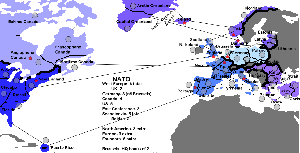
Rueben: the founding countries are marked with a star. these countries have a +5 bonus altogether. these are all the current members. ukraine, israel, ad about 50 other countries want to get in tho. the ussr had nothing to do with it. the usa hasn't even had a secretary general in nato yet. if i showed all of it, europe would be too small and people would start b*tching about it being another usa map.
Posted:
Sun Dec 31, 2006 10:32 amby Wisse
how to make textures in photoshop:
if you have a picture open, go to filter and select artistic, chose one and a window will pop up where you can see what happens with all the other things you can chose
Posted:
Sun Dec 31, 2006 10:33 amby happysadfun
I have inkscape.
Posted:
Sun Dec 31, 2006 10:33 amby Lone.prophet
or u can go 2 layer properties and select pattern overlay with a opacy of around 50 or something
Posted:
Sun Dec 31, 2006 10:34 amby happysadfun
good idea!
Posted:
Sun Dec 31, 2006 1:14 pmby AndyDufresne
Something you might want to consider, shrinking the actual distance between NA and Europe. Some of it will be uneeded space (do you plan to put the bonus legend there?), and I think you could size that down slightly.
You also need to consider a remedy for the streaking lines across the page...how you can make them better or find a better way to describe how to get from one area to the next.
--Andy
Posted:
Sun Dec 31, 2006 1:16 pmby hendy
do not use eskimo canada people find the word offensive inuit would be better
yeah
Posted:
Sun Dec 31, 2006 2:22 pmby kramsey06
i actually kinda like it. seems simple
Posted:
Sun Dec 31, 2006 3:49 pmby reverend_kyle
hendy wrote:do not use eskimo canada people find the word offensive inuit would be better
Or Arctic Canada..
I think he was trying to be funny

Posted:
Sun Dec 31, 2006 6:01 pmby happysadfun
How is Eskimo Candada offensive? I had to research them last year for school, and they are proud to be called Eskimos.
Much better, I think, than my last draft
TO DO
* Add gradient connections
* Get rid of all the blue
* Change Wisconsin and Florida to Milwaukee and Atlanta
* Reconstruct bonuses
* Remove thick borders
Posted:
Sun Dec 31, 2006 6:07 pmby Fircoal
A little less confusing, but the points you get of the continents are way off, from what they should be. Also, the colors are too close to each other.
Posted:
Sun Dec 31, 2006 6:12 pmby happysadfun
please tell me how i can remedy that. i wanted to keep them all bue because blue is the color of nato.
Posted:
Sun Dec 31, 2006 6:21 pmby Fircoal
happysadfun wrote:please tell me how i can remedy that. i wanted to keep them all bue because blue is the color of nato.
MAybe you shouldn't do that, because it's confusing, mainly in the key.
Posted:
Sun Dec 31, 2006 6:37 pmby Wisse
make all lines anather colore (make all lines that comes from one country the same color)
Posted:
Sun Dec 31, 2006 7:29 pmby Sargentgeneral
yeah, i think the blue idea needs to go. It looks better than the other one, but it is still a little messy.
Posted:
Sun Dec 31, 2006 9:16 pmby Ruben Cassar
happysadfun wrote:thanks, whee did you get the textures?
Rueben: the founding countries are marked with a star. these countries have a +5 bonus altogether. these are all the current members. ukraine, israel, ad about 50 other countries want to get in tho. the ussr had nothing to do with it. the usa hasn't even had a secretary general in nato yet. if i showed all of it, europe would be too small and people would start b*tching about it being another usa map.
Oh my God! I am sorry about my previous post! I seem to have had a kind of lapsus and confused this map with the Cold War map (NATO and Warsaw Pact). Apologies!
Posted:
Sun Dec 31, 2006 9:31 pmby AK_iceman
happysadfun wrote:How is Eskimo Candada offensive? I had to research them last year for school, and they are proud to be called Eskimos.
There's nothing wrong with the word Eskimo.