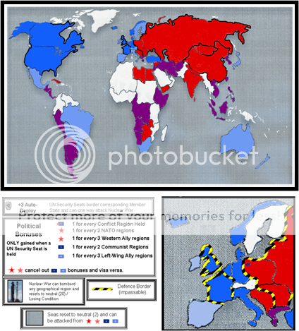
Industrial Helix wrote:I'm thinking that we should use the N. Atlantic for the Europe inset and maybe use the inset to cover the Middle east as well.
Yeah, I was thinking about that for an inset spot, although it leaves Iceland as a problem (the inset would cover Iceland but Iceland would then make the inset larger than necessary).
We're really going to have to distort the map to make this one work, I think. But really, look at the original Risk maps, they're quite distorted as well to make things playable. Plus, the inset can cover up some of Europe on the map, giving us more room.
I agree, there is room for a certain degree of distortion, although it may look wierd if distortion strays too far from the two 'traditional' styles of world map. Working between those styles is no problem, but once we get to the extent we have I am wondering whether the distorted map would need have some graphical feature such as an old-skool TV/computer screen style. The added curvature of old-skool screens gives licence for more distortion still looking cool. Maybe? Not sure if I have explained that right.
So Middle East needs to be stretched and Caribbean/Central America needs it as well. Africa fits well, but the West coast is a problem.
A stretched arabian peninsula would be cool, but how about palestine, part of the inset or part of the stretched peninsula? Including in the inset would, like the Iceland problem, mean the inset would need to be bigger. I've already meddled with central america but agree it could do with more expanding. I expanded south america but perhaps it doesn't need as much as it has?
We also need territory names.
Yeah, I left this as things were changing from diagram to diagram but now its time for them. Any ideas for how to name the northern and southern parts of the Eastern Bloc?
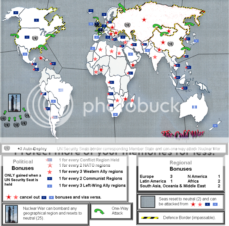
I think skipping the regional bonuses would be a good thing... the real bonuses are coming from winning the conflicts, not necessarily holding a geographical area, Cuba for example.
It will save space too.
In Indochina... what about adding Thailand to Indochina and moving the India border east. This eliminates Burma, but meh.
This kinda makes sense.
The seas... what about they can only be attacked in the areas with the arrows and can attack conflict areas? That way Mozambique can't win and then invade Mexico.
I wasn't sure if my diagram would make it clear what the seas can attack.
And I was also thinking about which regions should be able to attack the seas ... only problems with limiting to the superpowers are: (a) getting around the map at the beginning of the game (which can be partly solved by complex starting region combinations); and (b) we would possibly want a few regions like Cuba to be able to attack out as well as be attacked? Such things can be sorted later anyhow as they wont make much odds to the layout (just a little extra space in the legend).
Nuke War... what about no killer neutral and losing condition if held? I rather like that idea because it makes Nuke War a possibility but an undesirable.
I like this idea, although I also like the killer neutral idea, and having to hold a non-commander region to stay alive. Just wondering if there could be 2 features - Nuke War and Airborne War? If we stuck with just your idea, the auto-deploys on the commanders would be awkward as players would most likely want to reinforce them elsewhere (although this can be interesting tactically, such as in Pelo War).
The Xmas map is a good example of a killer neutral being able to bombard regions required to eliminate an opponent. Although holding the 25th is not a losing condition, a failed kill on the killer neutral is potentially fatal to the player attempting it as it allows an opponent to then take the 25th cheaply, finish the elimination off and potentially make additional progress / eliminations.
Anyway, either way, or both ways, we can discuss further and decide without having to make major layout changes.
Something like Japan can be moved East and enlargened, this would also give korea some room to be enlargened as well.
Yeah, Japan, Korea and Taiwan can get the treatment.
And lastly I'm thinking color codings might be better than symbols because it reduces the clutter and gives us room to fit numbers and names.
I think you're right here, although if there were room for symbols I think it would be more appealing graphically, especially as we could then have earthy colours for the land. But, you're right, we can't afford the space in most areas.
Also, what do you think to the right-left bonus cancellation idea (I think it was Sully's above) - bonuses are cancelled-out by holding both red and blue regions (although I think we should ensure conflict region bonuses aren't affected by this)?
Also, should the bonuses be dependant on holding a super-power as opposed to the UN seat? Or maybe both? This would make it more possible for a player to make a raid through the narrow routes to a super-power, which may then finish when coming up to a partly stacked 'commander' which can then hit back next round?