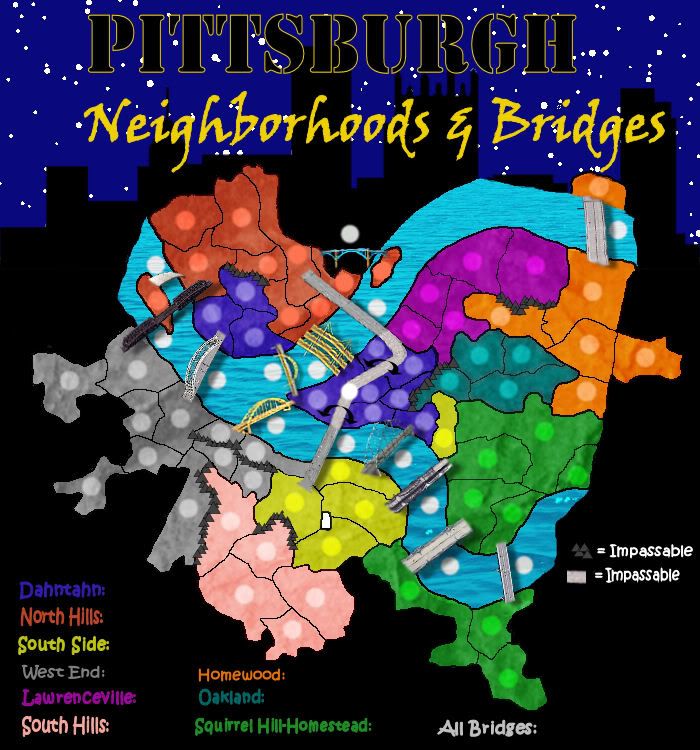
Pittsburgh: Neighborhoods & Bridges
"Pittsburgh: Neighborhoods & Bridges"
Map developed by League and ckdoeswork.
This map contains:
-79 Territories
-9 Continents
-15 conquerable bridges
Uniqueness: This would be the first Conquer Club map of Pittsburgh,
PA. This map uses Pittsburgh's neighborhoods as playable territories
and the troop bonus structure is based on the city's actual city
council districts. Bridges are playable territories which allow troop
movement between several neighborhoods. Furthermore, the map image
uses actual images of the actual bridges, making it all the more
realistic. While most bridges allow troop movements between nearby
territories, the Veterans Bridge - Crosstown Boulevard - Liberty
Bridge territories model Pittsburgh in two ways that make game play
interesting - first these bridges allow troop movement between
relatively distant territories on the map. Also, the crosstown
boulevard serves as an impassable between dahntahn and the hill
district, similar to the impact it has on the downtown area in
Pittsburgh. Also, the famous three rivers serve as impassables
between the major areas of the city. In reality, Pittsburgh is
nestled in the Appalachian mountains, and therefore we use mountains
as impassables in between some of the neighborhoods as well. Because
the bridges are so important, a player holding several of them
receives bonus troops.
- Click image to enlarge.