Conquer Club

Austria

Have an idea for a map? Discuss ideas and concepts here.

Moderator: Cartographers

Forum rules
Please read the Community Guidelines before posting.

Austria

Postby Minister X on Tue Aug 11, 2020 5:53 pm

Map Name:Austria
Mapmaker(s):Minister X
Number of Territories:TBD
Special Features:TBD
What Makes This Map Worthy of Being Made: Austria is the most recognizable country in Europe which does not yet have a CC map.

Map Image:
Image

European country-sized and larger areas (current and historical) with CC maps: Ancient Greece, Austro-Hungarian Empire, Balkan Peninsula, Baltic Crusades, Baltic States, BeNeLux, British Isles, Celtic Nations, Cyprus, Czecho Slovak Fragmentation, England, Europa, Europe, Europe 1914, France, France 1789, France 2.1, Germany, Holy Roman Empire, Iberia, Iceland, Ireland, Italy, Luxembourg, Macedonia, Magyarország, Malta, Napoleonic Europe, Netherlands, Nordic Countries, Portugal, Rail Europe, San Marino, Slovakia, Unification Germany, Unification Italy, Wales, WWII Eastern Front, WWII Europe, WWII Poland, WWII Western Front, and Yugoslavia.

WHY NOT AUSTRIA? Of the unmapped countries of western and central Europe, Austria is probably the most populous and famous, with the most historical significance.

Anyway... that's my excuse. ;)

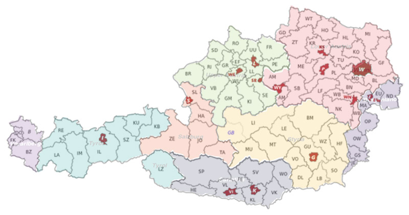
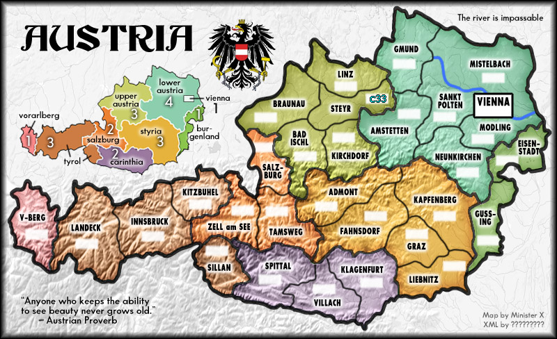
The map I've posted above shows eight "states" divided up into 79 "districts" and 15 "statutory cities". If all of these were used as terts this could be a huge map. By combining districts and ignoring all cities except perhaps Vienna and Innsbruck (with an air connection?) this could be made a quite small map (in terms of terts).

Austria is mountainous and the alpine areas occupy rather distinct parts of the country:

Image

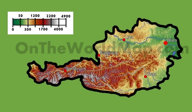
This presents both a challenge and an opportunity. I could simply place impassable mountain chains anywhere I wanted in that brown area or I could divide the country into two main areas, mountains and plains (or highlands and lowlands) and somehow devise different rules for each part. For instance, in the alpine region there would be some sort of penalty for crossing a border or some sort of delay in reaching the other side. I'd ask all of you who are much more familiar than I with the current state of XML to provide some creative ideas.

SHOULD I MAKE A MAP OF AUSTRIA AND RIGHT A TERRIBLE CC GEOGRAPHIC INJUSTICE? If so, small or large? With special rules or more standard?
User avatar
Major Minister X
 
Posts: 400
Joined: Tue Nov 11, 2008 4:45 pm

Re: Austria

Postby riskllama on Tue Aug 11, 2020 6:31 pm

i think i'd prefer a smaller map w/more standard gameplay.
Image
User avatar
Lieutenant riskllama
 
Posts: 8493
Joined: Thu Jan 30, 2014 9:50 pm
Location: deep inside Queen Charlotte.

Re: Austria

Postby pmac666 on Tue Aug 11, 2020 6:40 pm

as austrian i would really like to see that. :D
User avatar
Lieutenant pmac666
 
Posts: 67
Joined: Sat Jun 28, 2014 2:37 pm
323

Re: Austria

Postby Minister X on Wed Aug 12, 2020 1:36 am

So I went ahead and made a small (30-tert) simple map. But I don't like it, for reasons I'll explain below. It might actually be an interesting map to play, but there are problems.

Image

To me, the weirdest thing about this map is that I used no impassable mountains. When I first started thinking about this map it was because I recently found a great way to depict mountains and I wanted a mountainous region to map so I could use them. But once I decided to create just 30 terts instead of something like 80 things got tricky. Most of Austria is very mountainous. And the shape of the country means the mountainous part is isn't very wide. I'd have to make half the country totally impassable which would make for an impossible map. With these terts, if I chose just two or three borders to make impassable it would look ridiculous. And if you examine a road map of Austria you'll see that in fact there are major roads everywhere throughout the mountains. Here's such a map: http://www.vidiani.com/maps/maps_of_eur ... ustria.jpg

Using a relief map as a base as I've done gives the viewer a sense of just how mountainous Austria is. If I added just a few artificial mountains (i.e. between Tamsweg and Spittal) it would look silly. So it's either forget about impassable mountains or make a map with enough terts that the current Innsbruck tert would turn into nine terts so there's places to add lots of mountain-impassables. It would have to be one of the largest maps at CC.

So... even if this map were a masterpiece of the graphic arts (which it most certainly is not) I'd fully understand if it didn't get an overwhelmingly positive reception here.

Note: the bonus regions, which are called "states" in Austria, are drawn accurately. The subdivisions within the states generally follow the borders of the very numerous "districts" within those states but the names of my terts are taken somewhat arbitrarily from the names of the larger cities or towns within those terts. Thus these terts do not correspond to any actual adninistrative/governmental areas. They are made up of one to four actual districts and don't necessarily remain perfect true to even those combined borders. So if your taste for realism demands conformity with an accurate political map, that's yet another reason to reject this map.

Unfortunately, I don't think there's a way to make a map of Austria that's both politically accurate and includes mountain impassables that are even remotely realistic. Basically, it's either something like the map above or nothing. We can consider this thread, perhaps, as a proof-of-concept exercise that proved the concept was flawed. :sick:
User avatar
Major Minister X
 
Posts: 400
Joined: Tue Nov 11, 2008 4:45 pm

Re: Austria

Postby HitRed on Wed Aug 12, 2020 7:24 am

Minister X wrote:Unfortunately, I don't think there's a way to make a map of Austria that's both politically accurate and includes mountain impassables that are even remotely realistic.


The Map Makers Guide Book wrote:Image Form Must Follow Function - Expect to show some flexibility and be prepared to move away from complete geographical accuracy or historical authenticity: the look and theme of the map must be utterly subservient to gameplay and legibility.


You clearly conquered making mountains. It looks fun. It also looks like a CC map.

Note: The rectangle city doesn't fit the rest of the look somehow.

=D>

HitRed
User avatar
Major HitRed
 
Posts: 3370
Joined: Fri Jun 26, 2015 12:16 pm

Re: Austria

Postby ZaBeast on Wed Aug 12, 2020 10:26 am

I have two issues with that map
1- I hate 1-tert bonuses because someone usually lands them with the drop to give them a unfair +1, especially when it is as remote as you have it here. I would remove it or turn it neutral
2- I believe you should reduce the value of the tyrol bonus as it seems a lot easier to hold than any other (except the +1) given the limited number of borders it has (you could defend it by stacking on 2 terts, where the salzburg bonus for instance borders 8 terts)

I'm also personnally attracted to more complex maps but it looks fine
Image
Colonel ZaBeast
 
Posts: 323
Joined: Sat May 06, 2017 5:26 pm
432

Re: Austria

Postby Minister X on Wed Aug 12, 2020 11:05 am

The 1-bonuses would all start neutral.

Tyrol: as a separated region it would be harder to control than, say, Carinthia. And it's 4 terts whereas Carinthia is just 3. I think you overlooked "Silian". But bonuses are easy to adjust should playtest make that advisable. I doubt this map would ever get that far.

HitRed: thanks for that quote from The Map Makers Guide Book. That's very good to know.

BTW, given that quote, I might consider adding a river in "Upper Austria", perhaps making Linz and Steyr separated from Braunau and Bad Ischl.

The Vienna box: I know what you mean. I made it different for a weird reason based on Austrian nomenclature that I won't bother explaining. And I had planned on it having some special rule but then just made it a 1-bonus. If I make another version I'll turn it into a regular bonus region.

BUT GUYS... I MORE OR LESS POSTED THIS AS AN EXAMPLE OF A FAILED MAP. That long leg in the west, the inability to include mountain-impassables... if I myself don't even think this map is worthy (at least compared to some of my others) what hope does it have?? :o
User avatar
Major Minister X
 
Posts: 400
Joined: Tue Nov 11, 2008 4:45 pm

Re: Austria

Postby riskllama on Wed Aug 12, 2020 11:58 am

just drawing your new pretty mountains w/standard gameplay doesn't do it for you, MinX? i quite like the 3rd iteration as is... :) .
maybe tweak the bonus values a bit, tho...
Image
User avatar
Lieutenant riskllama
 
Posts: 8493
Joined: Thu Jan 30, 2014 9:50 pm
Location: deep inside Queen Charlotte.

Re: Austria

Postby HitRed on Wed Aug 12, 2020 12:03 pm

I don't view this as failed. I see quality.
User avatar
Major HitRed
 
Posts: 3370
Joined: Fri Jun 26, 2015 12:16 pm

Re: Austria

Postby Minister X on Wed Aug 12, 2020 1:15 pm

I should always write in my initial map posts: ALL BONUS VALUES ARE COMPLETELY TENTATIVE. :)

(And I must remember to specify which terts must start neutral.)

Another European country which has not yet been honored with a map is Ukraine. It's shape and geography are more conducive to CC mapmaking. Gee... I wonder if anyone will soon post a map of UKRAINE? (hint, hint...)
User avatar
Major Minister X
 
Posts: 400
Joined: Tue Nov 11, 2008 4:45 pm

Re: Austria

Postby HitRed on Wed Aug 12, 2020 2:50 pm

Minister X wrote:I should always write in my initial map posts: ALL BONUS VALUES ARE COMPLETELY TENTATIVE. :)


My view on bonuses. One bonus shouldn't impact the game. I like to allow the game to ebb and flow early with random dice.
User avatar
Major HitRed
 
Posts: 3370
Joined: Fri Jun 26, 2015 12:16 pm

Re: Austria

Postby Minister X on Wed Aug 12, 2020 4:34 pm

I totally agree and would emphasize: if the map allows for the early capture of a small bonus, it should allow for two or more so that an early jump-start by one player can be counteracted quickly by one or two others.
User avatar
Major Minister X
 
Posts: 400
Joined: Tue Nov 11, 2008 4:45 pm

Re: Austria

Postby Dukasaur on Wed Oct 28, 2020 4:41 pm

Minister X wrote:So I went ahead and made a small (30-tert) simple map. But I don't like it, for reasons I'll explain below. It might actually be an interesting map to play, but there are problems.

Image

To me, the weirdest thing about this map is that I used no impassable mountains. When I first started thinking about this map it was because I recently found a great way to depict mountains and I wanted a mountainous region to map so I could use them. But once I decided to create just 30 terts instead of something like 80 things got tricky. Most of Austria is very mountainous. And the shape of the country means the mountainous part is isn't very wide. I'd have to make half the country totally impassable which would make for an impossible map. With these terts, if I chose just two or three borders to make impassable it would look ridiculous. And if you examine a road map of Austria you'll see that in fact there are major roads everywhere throughout the mountains. Here's such a map: http://www.vidiani.com/maps/maps_of_eur ... ustria.jpg

Using a relief map as a base as I've done gives the viewer a sense of just how mountainous Austria is. If I added just a few artificial mountains (i.e. between Tamsweg and Spittal) it would look silly. So it's either forget about impassable mountains or make a map with enough terts that the current Innsbruck tert would turn into nine terts so there's places to add lots of mountain-impassables. It would have to be one of the largest maps at CC.

So... even if this map were a masterpiece of the graphic arts (which it most certainly is not) I'd fully understand if it didn't get an overwhelmingly positive reception here.

Note: the bonus regions, which are called "states" in Austria, are drawn accurately. The subdivisions within the states generally follow the borders of the very numerous "districts" within those states but the names of my terts are taken somewhat arbitrarily from the names of the larger cities or towns within those terts. Thus these terts do not correspond to any actual adninistrative/governmental areas. They are made up of one to four actual districts and don't necessarily remain perfect true to even those combined borders. So if your taste for realism demands conformity with an accurate political map, that's yet another reason to reject this map.

Unfortunately, I don't think there's a way to make a map of Austria that's both politically accurate and includes mountain impassables that are even remotely realistic. Basically, it's either something like the map above or nothing. We can consider this thread, perhaps, as a proof-of-concept exercise that proved the concept was flawed. :sick:


It's a nice map.

I don't think the flaws are fatal. You're right -- you either have to make all the mountain borders impassable, or none. Having just a few impassable borders there would be silly. Since 60% of the country is mountainous, making a lot of impassable borders would make it almost unplayable. So my vote is for none. Which is realistic. The Alps have been occupied for thousands of years. People have been walking through the passes as far back as the Stone Age, so they're not impassable. So keep the mountains for their aesthetic value, but ignore them for gameplay.

I think it's actually a good, playable map, as is. The smaller regions have few borders, the bigger regions have many borders, which is basically what creates balance between them. and Ian's mathematical wizardry will do the rest.

I agree with Hitred that the triangle is out-of-place. Use the actual shape of Vienna, just expand it to a playable size.
Image
User avatar
Captain Dukasaur
Community Team
Community Team
 
Posts: 25031
Joined: Sat Nov 20, 2010 4:49 pm
Location: Beautiful Niagara
22


Return to Melting Pot: Map Ideas

Who is online

Users browsing this forum: No registered users

cron