Page 2 of 2
Re: Africa
Posted: Wed Jun 17, 2009 9:08 pm
by petrie000
pimphawks70 wrote:Peter Gibbons wrote:Tupence wrote:
The USA map pack has proved hugely popular - any thoughts on an African equivalent?
Hmm.
Maghreb, Sahara, Horn, Gulf of Guinea/West Africa, Sub-Sahara, Southern Africa.
Six pretty good regions to work with. You might be onto something.
Interesting idea, but what would a map of the Sahara look like?
'regions' seperated by vast expanses of impenetrable desert instead of oceans, basically. you've got the Tunisia/Algiers/Carthage area to the northwest, Egypt and Libya in the northeast. Sudan and Abyssinia to the southeast and Mali/Timbukto to the southwest. there's probably more, but that's just what i know off the top of my head in terms of historical native empires in the region.
Re: Africa
Posted: Thu Jun 18, 2009 9:31 am
by Sharpsh00ter
'regions' seperated by vast expanses of impenetrable desert instead of oceans, basically. you've got the Tunisia/Algiers/Carthage area to the northwest, Egypt and Libya in the northeast. Sudan and Abyssinia to the southeast and Mali/Timbukto to the southwest. there's probably more, but that's just what i know off the top of my head in terms of historical native empires in the region.
You could have caravan routes and oasis's in between. Sounds very interesting and a new twist on it. Negitive bonuses or even killer neutrals on the caravan routes to show the harshness of the climate.
C
Re: Africa
Posted: Thu Jun 18, 2009 9:44 am
by pimphawks70
petrie000 wrote:pimphawks70 wrote:Peter Gibbons wrote:Tupence wrote:
The USA map pack has proved hugely popular - any thoughts on an African equivalent?
Hmm.
Maghreb, Sahara, Horn, Gulf of Guinea/West Africa, Sub-Sahara, Southern Africa.
Six pretty good regions to work with. You might be onto something.
Interesting idea, but what would a map of the Sahara look like?
'regions' seperated by vast expanses of impenetrable desert instead of oceans, basically. you've got the Tunisia/Algiers/Carthage area to the northwest, Egypt and Libya in the northeast. Sudan and Abyssinia to the southeast and Mali/Timbukto to the southwest. there's probably more, but that's just what i know off the top of my head in terms of historical native empires in the region.
ohhhhh... now that sounds interesting
Re: Africa
Posted: Fri Jun 19, 2009 2:20 am
by petrie000
you'd have to expand beyond what's strictly known as the Sahara and in to a region known at the Sahela, as well as take some liberties with time frames, but there's actually quite a bit of native African Kingdoms below the desert proper.
Re: Africa
Posted: Fri Jun 19, 2009 5:22 am
by thenobodies80
The African Continents is a good place for new maps...
My only concerns is about the unstable/sensitive political situation of these zones...

Maybe the hot italian summer holidays can give to me a sort of inspiration.
And....if i realize where i put my tablet...

Re: Africa
Posted: Fri Jun 19, 2009 6:30 am
by petrie000
i've been looking on Wikipedia for historical references (hey, it's a good place to go for one-stop-shopping to much more accurate links), and i think i can put together enough historically accurate region names if somebody can find a good map. i can't do the map design for technical reasons, but as a man with a lot of time on his hands and an unnatural love ob obscure history i'd be more than happy to pair up with an experienced cartographer to see if we can't flesh this out a bit.
Re: Africa
Posted: Sat Jun 20, 2009 8:35 pm
by neanderpaul14
AndyDufresne wrote:neanderpaul14 wrote:Darthvadar wrote:i like the idea of Zulu Kingdom, plenty you could do with that i feel
More specifically how about a Battle of Isandlwana or Rorke's Drift
Rorke's Drift...mmhm, I'm thinking Michael Caine in Zulu.

I like the idea.
--Andy
Great movie, I remember when I was a kid, and only had 3 TV stations, that would come on the Saturday afternoon movie every couple of months and I'd watch the whole thing every time.
Re: Africa
Posted: Sun Jun 21, 2009 10:35 am
by oaktown
petrie000 wrote:i've been looking on Wikipedia for historical references (hey, it's a good place to go for one-stop-shopping to much more accurate links), and i think i can put together enough historically accurate region names if somebody can find a good map. i can't do the map design for technical reasons, but as a man with a lot of time on his hands and an unnatural love ob obscure history i'd be more than happy to pair up with an experienced cartographer to see if we can't flesh this out a bit.
Do you have a rudimentary drawing program that you could use to make the early drafts? These days I'd be more inclined to starting a new project if somebody else were willing to do the initial work of coming up with a playable and geographically accurate layout, and I was just the pen.
In looking at the regions suggested earlier there is a lot of cross-over in terms of where regional lines are drawn. Maghreb was historically considered to be a much smaller region than it is today, and now includes much of the Sahara. Sub-Saharan Africa is huge and includes everything south of the Sahara, including Southern Africa and the gulf coast region.
The map I could be most easily talked into making would be that of Southern Africa, encompassing the areas of Bantu expansion. It could work as a historical or contemporary map.
Re: Africa
Posted: Sun Jun 21, 2009 9:22 pm
by petrie000
um, i could try to draw something, but i fear i'm really not much of an artist. i do have a rough idea on the divisional boundaries that would make the most sense, at least to me.
Re: Africa
Posted: Mon Jun 22, 2009 3:15 am
by petrie000
Here's what i found as starting points on a Sahara map. if you wanna keep it African and not just another roman or egyptian spin off, you're best route is to focus on the Trade empires that sprung up around it and the trade routes through it. you don't need a lot of fancy gameplay rules, just do a standard conquest map, except that instead of oceans separating the Regions, you just have 'em broken up by deserts.
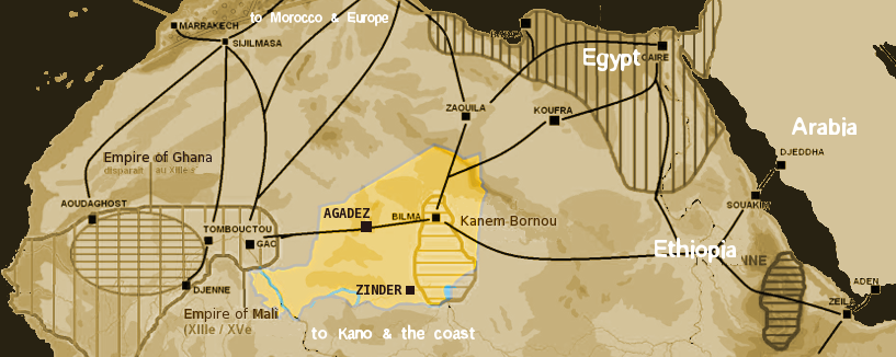
this i thought was a very useful map outlining the general placement of the Regions. Morroco and Egypt in the northwest and northeast, respectively, Khanem-Bornou in the center, and Ghana and Ethopia to the Southwest and Southest. not a rough draft, just some historical information to give an idea of the concept.
obviously that won't work as a starting map, but i'd need some help from more experienced cartographers to tell me good places to look for better graphics. that's just a good example of the geographical region we'd be dealing with.
Re: Africa
Posted: Mon Jun 22, 2009 3:22 pm
by eigenvector
What are the curved lines? Trade routes?
Re: Africa
Posted: Mon Jun 22, 2009 9:12 pm
by petrie000
pretty much, yes. this shows the major trade centers in the area, which is what the individual Territories would be based off of.
Re: Africa
Posted: Tue Jun 23, 2009 7:39 pm
by oaktown
not sure exactly how that translates into a CC map... while trade routes could add an interesting twist to a CC map, the trade route lines are useless for the initial work of breaking the region up into standard territories and regions.
To begin with we need something more straightforward...

or

Seems the UN splits Africa into five regions:
* Northern Africa
* Western Africa
* Middle Africa
* Eastern Africa
* Southern Africa
Five maps?
Re: Africa
Posted: Tue Jun 23, 2009 8:03 pm
by cairnswk
Would this be of any assistance?

Re: Africa
Posted: Tue Jun 23, 2009 10:26 pm
by AndyDufresne
There are a lot good ideas in here---now we just need some action.
--Andy
Re: Africa
Posted: Tue Jun 23, 2009 10:36 pm
by petrie000
if we're gonna do a series of maps, it would make sense to give them all the same general feel, right? maybe we should move this to the Drafts section and and find a single map of Africa we can work with, then break it down in to five separate sections.
Re: Africa
Posted: Tue Jun 23, 2009 11:05 pm
by oaktown
petrie000 wrote:if we're gonna do a series of maps, it would make sense to give them all the same general feel, right?
That would look sweet, but be five times the work. I'm having trouble keeping up with the maps I have already, so if I'm going to come on with this project I'd like to focus on one map.
That doesn't mean there can't be other people working on other regions of Africa simultaneously, but it would be really difficult for three mapmakers to make three maps and achieve the same look.
petrie000 wrote:maybe we should move this to the Drafts section and and find a single map of Africa we can work with, then break it down in to five separate sections.
Sure, but first we need a draft!

Personally I'd be interested in either doing Southern Africa or the Horn. I'm happy to do the artwork, but I'd love it if somebody was able to do the leg work of sorting out what the bonus regions would be (the countries with that region I assume) and how to break those regions into territories that would work as a CC game. In fact, of somebody was able to do that and spend a few weeks getting the gameplay more or less squared away on each map I might be able to pick up one project at a time as they are ready. Division of tasks would significantly decrease the workload on the artist.
Re: Africa
Posted: Tue Jun 23, 2009 11:16 pm
by petrie000
as stated before, i have no java capability so my ability to help is limited. i did, hoever, spent about ten years pouring over maps of the world just as a hobby, so i could be of some use in breaking down the regions into smaller chunks.
Re: Africa
Posted: Fri Jun 26, 2009 8:41 pm
by captainwalrus
I'm working on a WW1 east african map based on a map andy D posted in another thread, but I don't know if I will stick with that.
Re: Africa
Posted: Sat Jun 27, 2009 3:50 am
by shakeycat
I'm looking into some Africa options too. I'm hoping to explore present day themes of resources, international trade, and conflict, but I'm still researching, sketching possibilities. Maybe Angola. Maybe the whole thing.
Thinking of USA Apocalypse, I tossed around the idea of Africa Apocalypse for all of ten minutes. There are many articles to back up the future-Africa vision. It's beyond the 'Global Warming' map with the encroaching water and heat. As with anything, how do we translate a big idea into a fun, playable map.
I look forward to seeing more Africa maps, and learning more about Africa in the process. It is an often ignored continent on the world stage.
Re: Africa
Posted: Sat Jun 27, 2009 6:02 am
by petrie000
i tell ya', finding good maps you adapt is really, really hard, though. where do you professionals go to find these things?
Re: Africa
Posted: Sat Jun 27, 2009 10:28 am
by captainwalrus
- Click image to enlarge.

This is the one I'm using. Andy D. posted it somewhere.
Re: Africa
Posted: Mon Jun 29, 2009 5:52 am
by Industrial Helix
I'm glad to see so much enthusiasm for Africa all of a sudden and I'm glad it could be prompted.
Did this when I had some free time earlier this month... I'm afraid I can't continue it at the moment as I need to be putting full energy towards my 13 colonies map.... But i would like to see this through completion.
- Click image to enlarge.
