
If this hasn't been brought up before then wow im very suprised
but what do you think of this idea of having the England Capital as a map.


Moderator: Cartographers

sure, but find an inhabitant who has the time and skills. I think if a local paired up with one of our regular mapmakers this could make for a great collaborative map. if somebody who really knows the city is serious about making this happen, I'm willing to talk with them.InkL0sed wrote:They pretty much need to be made by an inhabitant. Hence why NYC turned out so well.

Simple, get iancanton to make the decisionoaktown wrote:2) everybody who has ever lived in/visited/read a wikipedia entry about he city thinks he's an expert, so there is endless arguing over where to draw borders and what to call everything.

Top Score:2403natty_dread wrote:I was wrong


I couldnt think of anthing worsewhitestazn88 wrote:i actually thought a tourists map of london would be cool, with the tower of london, buckingham palace, soho, the eye, big ben, etc. as bonuses like that crapped out san diego map had
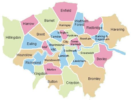
well it seems as though that makes one vote for, and one vote against tourist mapcena-rules wrote:I couldnt think of anthing worsewhitestazn88 wrote:i actually thought a tourists map of london would be cool, with the tower of london, buckingham palace, soho, the eye, big ben, etc. as bonuses like that crapped out san diego map had

Their alot harder thoughoaktown wrote:here are some maps that are more along the lines of what I'd like to see done... careful, the first one is a large file.
http://www.writewellgroup.com/Shakespea ... 1593-b.jpg
http://upload.wikimedia.org/wikipedia/e ... f_1673.JPG
http://upload.wikimedia.org/wikipedia/c ... ighton.JPG



no that was just how many places there arewhitestazn88 wrote:33 bonuses?