Settlers [New Poll] [need some graphics help.]
Moderator: Cartographers
Forum rules
Please read the Community Guidelines before posting.
Please read the Community Guidelines before posting.

Re: Settlers [Poll] [Update-roads]
I've contacted Mayfair about possibly using the Catan terms (pointing out that it could very easily pen up a new market for them, as this will NOT be the catan game, but MAY spark interest, meaning more customers for them.  ) I have yet to hear back.


Re: Settlers [Poll] [Update-roads]
nice map. sounds like AOR maps that have paris for bonuses.

16:00:18 ‹Pixar› Valentines Day the one day in they year that the V and the D come together
Re: Settlers [Poll] [Update-roads]
40kguy wrote:nice map. sounds like AOR maps that have paris for bonuses.
mmmm, sorta, ya, I guess. and Middle ages, because I think I'm going to go with the suggested "must hold at least one town" thing.
Re: Settlers [Poll] [Update-roads]
Well, I've rewritten the key, but I'll wait for more suggestions if there are any before going on to post another update.

Re: Settlers
Evil DIMwit wrote:Mr_Adams wrote:There aren't to few maps where 2 players are determined solely by dice and drop.
Really? In my impression, victory in Catan is entirely determined by dice and drop.
One could say the same for every Conquer Club Game I've been in ... especially the dice. I think the third element in both games is strategy, and in some CC variants of course, there are also opportunities for teamwork and cooperation.
But one advantage of Catan that we would do well to emulate, is the initial drop ... which they stagger. So in a 2-player game, instead of the first guy getting 12 men for example on the start of his turn, with the Catlan approach, he would get 6 ... and the 2nd guy would get the full 12 (or whatever was left after the first guy's turn).
I've often thought that would make for a much fairer game ... then you could only be screwed by the dice.
NVR
Re: Settlers [Poll] [Update-roads]
Haha, yes, the dice are fun, aren't they? I never thought of staggering the deployment. Take that to suggestions! =P For big maps, they could stagger it for larger games (eg. a large map like hive where you get +15. Player 1 gets 5, 2 gets 7, 3 gets 9 etc.) =P
Back on topic. THE MAP! WHAT OF IT?
Back on topic. THE MAP! WHAT OF IT?
Re: Settlers [Poll] [Update-roads]
another potential numbering system:

Dead center would be (0,0,0), just above and to the left, (1,-1,0), then, clockwise, (1,0,1), (0,1,1), (-1,1,0), (-1,1,0), (-1,0,-1) and so on.
Just a working system.
Dead center would be (0,0,0), just above and to the left, (1,-1,0), then, clockwise, (1,0,1), (0,1,1), (-1,1,0), (-1,1,0), (-1,0,-1) and so on.
Just a working system.
Re: Settlers [Poll] [Update-roads]
I think that's very complicated to figure out. Both of them.
If we're talking about just using these for foundry discussions I think you should just stick any old marker on them. Numbers, letters, whatever, as long as I don't have to calculate my way through to some territory at the edge.
If we're talking about just using these for foundry discussions I think you should just stick any old marker on them. Numbers, letters, whatever, as long as I don't have to calculate my way through to some territory at the edge.

Re: Settlers [Poll] [Update-roads]
It's a very simple 3 coordinate access. And with the new site clickies, it doesn't need to be easy. 
Re: Settlers [Poll] [Update-roads]
Just took another look, I could actually take out the bottom set of coordinates. then it would be 2 coordinates. much less confusing, though really just as simple.
Re: Settlers [Poll] [Update-roads]
You can stick coloured gummy bears on them for all I care, as long as I don't have to do math to find the territory in question.
Re: Settlers [Poll] [Update-roads]
it's not math, it's only as complex as latitude and longitude... at the polls. 
-
natty dread

- Posts: 12877
- Joined: Fri Feb 08, 2008 8:58 pm
- Location: just plain fucked


Re: Settlers [Poll] [Update-roads]
This looks great. If you haven't seen it yet, I started hashing out some ideas for a similar map about a year ago. I never followed through on it, and yours is definitely better developed. But it might be worth looking at for some of the bonus ideas I was thinking about. See here:
viewtopic.php?f=63&t=109113
One of the things I was doing to try and stay away from any potential copyright issues was to use terms like farm and village/town instead of Settlement and City. Instead of ports, I had markets (shipyards would be a good term too). I was trying to work out a way to give bonuses based on resources controlled that would have some relation to the original game.

Re: Settlers [Poll] [Update-roads]
If the site had the XML to sustain it, resource trading.... COME ON SHEEEEEEEEP!!!!!
Re: Settlers [Poll] [Update-roads]
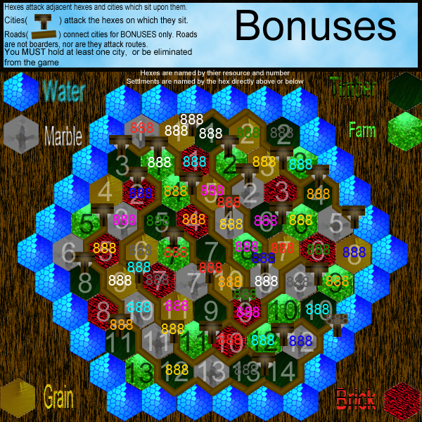
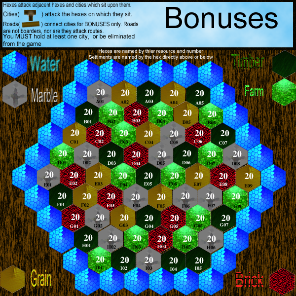
Ok, here is the numbering system used in the Hive map
I'll leave this as a separate piece to be approved, then work towns on to it.
I'll leave this as a separate piece to be approved, then work towns on to it.
Re: Settlers [Poll] [Update-roads]
Nice, though I would have preferred gummy bears 
As for the placement of cities, how about something nice and fair? Something like:
Top:
B02
B05
Bottom:
H02
H05
Left:
C01
G01
Right:
C07
G07
I think that should provide a nice distribution of the players.
Well, I guess I'm assuming 8 starting territories here. Maybe they'll all be non-neutral?
As for the placement of cities, how about something nice and fair? Something like:
Top:
B02
B05
Bottom:
H02
H05
Left:
C01
G01
Right:
C07
G07
I think that should provide a nice distribution of the players.
Well, I guess I'm assuming 8 starting territories here. Maybe they'll all be non-neutral?
Re: Settlers [Poll] [Update-roads]
I was planning on 25 starting territories (see 1st post), which would give 3 a piece in 8 and 7 man, 4 in 6 man, 5 in 5 man (the only time there wouldn't be a neutral), 7 in 3 man, 12 in 1v1. (though perhaps there would be more neutrals... maybe make it 7 in 1v1, 5 in 3 etc.)
besides, you would've eaten the gummy bears!
besides, you would've eaten the gummy bears!
-
Night Strike

- Posts: 8512
- Joined: Wed Apr 18, 2007 3:52 pm
- Gender: Male
Re: Settlers [Poll] [Update-labeling system]
1. Decrease the size of the resource keys so you can slightly increase the size of the playable areas: the hexes currently seem REALLY squished together.
2. Add ports to the water in certain places that will be able to attack each other to provide more flow of movement. You could also make it so 2:1 ports attack each other and 3:1 attack each other.
3. The colors do not look good yet. You also need to improve the contrast between the roads/cities and resources like grain: they all just bleed together into a muddled mess. You also have several hexes that have cracks in them.
4. I'm guessing you can't use roads, settlements, and cities; so I'd change them to something like paths, villages, and towns.

Re: Settlers [Poll] [Update-labeling system]
Night Strike wrote:1. Decrease the size of the resource keys so you can slightly increase the size of the playable areas: the hexes currently seem REALLY squished together.
2. Add ports to the water in certain places that will be able to attack each other to provide more flow of movement. You could also make it so 2:1 ports attack each other and 3:1 attack each other.
3. The colors do not look good yet. You also need to improve the contrast between the roads/cities and resources like grain: they all just bleed together into a muddled mess. You also have several hexes that have cracks in them.
4. I'm guessing you can't use roads, settlements, and cities; so I'd change them to something like paths, villages, and towns.
1) must I do these things in the drafting room? Seems like graphics workshop to me. =P I'll see what I can do. I've already decided to make some changes to the towns, to make them look better, when I get around to it.
2)I don't really like this idea. there are no borders as of yet, so it seems to me that the board is open enough already, no?
3)Colors are not going to survive long. I've already redone the red one. =P
4)maybe settlements and cities, but it'd be quite a stretch to say you can't call connections between towns "roads"
Re: Settlers [Poll] [Update-labeling system]
I think I may have missed a big part of the concept here. What do you mean 'there are no borders'?
Re: Settlers [Poll] [Update-labeling system]
I mean the roads aren't barriers. Even if there is a road on the border between A1 and B1, they still attack eachother.
Re: Settlers [Poll] [Update-labeling system]
Mr_Adams wrote:1) must I do these things in the drafting room? Seems like graphics workshop to me. =P I'll see what I can do. I've already decided to make some changes to the towns, to make them look better, when I get around to it.
2)I don't really like this idea. there are no borders as of yet, so it seems to me that the board is open enough already, no?
3)Colors are not going to survive long. I've already redone the red one. =P
4)maybe settlements and cities, but it'd be quite a stretch to say you can't call connections between towns "roads"But should it become necessary, it can be done.
1) Yes it is a good idea to do it know as then we will have a better idea of what direction you are going in.
It looks like you are starting on the small map first. If you are doing it in vector graphics that's fine, but if not, well you'll have to do the large from scratch. My suggestion is to do the large and then from time to time you can shrink it down to the small to make sure everything fits.
Re: Settlers [Poll] [Update-labeling system]
I have it in photoshop. I should be able to compress the file, then paste and expand on a larger page, right? :/
And perhaps I should respond to this more seriously.
The numbers I had on there were MUCH larger than the game numbers. It shouldn't be a problem with size 8 (I think that's what it is?) font. I will need room in the key to put the bonus info in the future. I would prefer to wait until the bonuses are decided upon to start setting the size of the key.
And perhaps I should respond to this more seriously.
Night Strike wrote:1. Decrease the size of the resource keys so you can slightly increase the size of the playable areas: the hexes currently seem REALLY squished together.
The numbers I had on there were MUCH larger than the game numbers. It shouldn't be a problem with size 8 (I think that's what it is?) font. I will need room in the key to put the bonus info in the future. I would prefer to wait until the bonuses are decided upon to start setting the size of the key.