

South Africa [I'll come back to it eventually] [Vacation]
Moderator: Cartographers
Forum rules
Please read the Community Guidelines before posting.
Please read the Community Guidelines before posting.
-
happysadfun

- Posts: 1251
- Joined: Mon Jul 10, 2006 9:06 pm
- Location: Haundin at DotSco, Being Sad that Mark Green Lost in Suburban Wisconsin
South Africa [I'll come back to it eventually] [Vacation]
Working on this s-africa map. Good idea?
Last edited by happysadfun on Tue Oct 17, 2006 3:52 pm, edited 1 time in total.
 Children, this is what happens to hockey players, druggies, and Hillary Clinton.
Rope. Tree. Hillary. Some assembly required.

-
happysadfun
- Posts: 1251
- Joined: Mon Jul 10, 2006 9:06 pm
- Location: Haundin at DotSco, Being Sad that Mark Green Lost in Suburban Wisconsin
-
AndyDufresne
- Posts: 24935
- Joined: Fri Mar 03, 2006 8:22 pm
- Location: A Banana Palm in Zihuatanejo
- Contact:
-
happysadfun
- Posts: 1251
- Joined: Mon Jul 10, 2006 9:06 pm
- Location: Haundin at DotSco, Being Sad that Mark Green Lost in Suburban Wisconsin
-
gavin_sidhu
- Posts: 1428
- Joined: Mon May 22, 2006 6:16 am
- Location: Brisbane, Australia
Its good to see you gave up your Wisconsin map.
I really think you should make an ancient egypt map. Your riverboat idea would work really good with that.
If you were going to make a South Africa map, what would you do about lesotho and swaziland? It would have to be grayed out. All maps of a country dont include territories of other countries (eg. Canada doesnt include greenland or alaska, Brazil contains no other country same with USA). A South Africa map by itself does not have much appeal, but if you set it in the arparthied period that would change. Maybe you should make a Southern Africa map and include nambia and stuff.
But i really really think you should make an ancient egypt map with the boat idea.
I really think you should make an ancient egypt map. Your riverboat idea would work really good with that.
If you were going to make a South Africa map, what would you do about lesotho and swaziland? It would have to be grayed out. All maps of a country dont include territories of other countries (eg. Canada doesnt include greenland or alaska, Brazil contains no other country same with USA). A South Africa map by itself does not have much appeal, but if you set it in the arparthied period that would change. Maybe you should make a Southern Africa map and include nambia and stuff.
But i really really think you should make an ancient egypt map with the boat idea.
Highest Score: 1843 Ranking (Australians): 3
-
happysadfun
- Posts: 1251
- Joined: Mon Jul 10, 2006 9:06 pm
- Location: Haundin at DotSco, Being Sad that Mark Green Lost in Suburban Wisconsin
yeah... i was thinking about all of those, but right now i'm doing modern south africa. the apartheid era would be ok, but the bophuthatswana homeland was so split around... and there was only four states: natal, orange free state, transvaal, and cape. the original map i started had lesotho on it, but i deleted lesotho.
Children, this is what happens to hockey players, druggies, and Hillary Clinton.Rope. Tree. Hillary. Some assembly required.
-
happysadfun
- Posts: 1251
- Joined: Mon Jul 10, 2006 9:06 pm
- Location: Haundin at DotSco, Being Sad that Mark Green Lost in Suburban Wisconsin
-
happysadfun
- Posts: 1251
- Joined: Mon Jul 10, 2006 9:06 pm
- Location: Haundin at DotSco, Being Sad that Mark Green Lost in Suburban Wisconsin
virginia was a common name for places at the time, because of a name of a powerful english company that was the virginia company and whatnot and administered a lot of places. so a lot of places are called virginia. but i agree welkom is better
Children, this is what happens to hockey players, druggies, and Hillary Clinton.Rope. Tree. Hillary. Some assembly required.

-
happysadfun
- Posts: 1251
- Joined: Mon Jul 10, 2006 9:06 pm
- Location: Haundin at DotSco, Being Sad that Mark Green Lost in Suburban Wisconsin
-
happysadfun
- Posts: 1251
- Joined: Mon Jul 10, 2006 9:06 pm
- Location: Haundin at DotSco, Being Sad that Mark Green Lost in Suburban Wisconsin
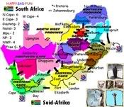
Suggestions?
34 countries, 9 continents (Northern Cape, Western Cape, Eastern Cape, Natal, Free State, Northwest Province, Northern Province, Gauteng, Mpumalanca)
Last edited by happysadfun on Mon Aug 14, 2006 12:18 pm, edited 1 time in total.
Children, this is what happens to hockey players, druggies, and Hillary Clinton.Rope. Tree. Hillary. Some assembly required.
-
happysadfun
- Posts: 1251
- Joined: Mon Jul 10, 2006 9:06 pm
- Location: Haundin at DotSco, Being Sad that Mark Green Lost in Suburban Wisconsin
-
gavin_sidhu
- Posts: 1428
- Joined: Mon May 22, 2006 6:16 am
- Location: Brisbane, Australia
-
happysadfun
- Posts: 1251
- Joined: Mon Jul 10, 2006 9:06 pm
- Location: Haundin at DotSco, Being Sad that Mark Green Lost in Suburban Wisconsin
-
Ronaldinho
- Posts: 3069
- Joined: Sat May 27, 2006 5:35 pm
- Gender: Male
- Location: Dorset, England.
-
happysadfun
- Posts: 1251
- Joined: Mon Jul 10, 2006 9:06 pm
- Location: Haundin at DotSco, Being Sad that Mark Green Lost in Suburban Wisconsin
-
happysadfun
- Posts: 1251
- Joined: Mon Jul 10, 2006 9:06 pm
- Location: Haundin at DotSco, Being Sad that Mark Green Lost in Suburban Wisconsin
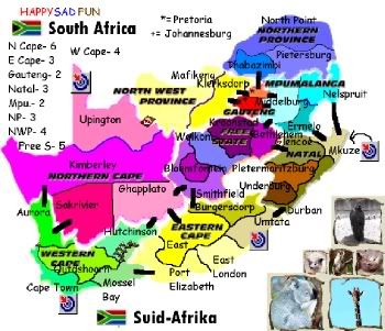
How beautiful! Gigantic countries without reason, and some tiny countries with the name in a legend...
Ok, its a bit unusual, 9 continents and 34 countries... I think it can be interesting, but add at least 2 more countries and remove a continent, dont you agree?
And when you have a bigger image, we can comment more about playability.
Ok, its a bit unusual, 9 continents and 34 countries... I think it can be interesting, but add at least 2 more countries and remove a continent, dont you agree?
And when you have a bigger image, we can comment more about playability.
-
happysadfun
- Posts: 1251
- Joined: Mon Jul 10, 2006 9:06 pm
- Location: Haundin at DotSco, Being Sad that Mark Green Lost in Suburban Wisconsin
-
gavin_sidhu
- Posts: 1428
- Joined: Mon May 22, 2006 6:16 am
- Location: Brisbane, Australia
ugh the colouring scheme. Free State and Northern Cape colour schemes are two similar. I dont get why you put continents of similar colours next to each other (eg. Mpumalanga and Northern Province, Northern Cape and Free State, Eastern Cape and Natal).
What are those symbols you have on Mkuze, Cape Town and Umtata.
Is North West povince worth 4 even though it only has two countries? Is Northern Province worth 3 even though it only has three countries? Your worth of your countries seem to be abit inflated.
My biggest problem with your map is i swear that animal at the bottom left of your design is a koala. Koalas arent from South Africa.
Since your going to have to redo this map again (the minimum you have to do is make it larger and you would have to create a new one to do that or youll have a long time fixing the pixels up) I think you should make an ancient egypt map. This map doesnt even have a river and a river boat.
What are those symbols you have on Mkuze, Cape Town and Umtata.
Is North West povince worth 4 even though it only has two countries? Is Northern Province worth 3 even though it only has three countries? Your worth of your countries seem to be abit inflated.
My biggest problem with your map is i swear that animal at the bottom left of your design is a koala. Koalas arent from South Africa.
Since your going to have to redo this map again (the minimum you have to do is make it larger and you would have to create a new one to do that or youll have a long time fixing the pixels up) I think you should make an ancient egypt map. This map doesnt even have a river and a river boat.
Highest Score: 1843 Ranking (Australians): 3
-
happysadfun
- Posts: 1251
- Joined: Mon Jul 10, 2006 9:06 pm
- Location: Haundin at DotSco, Being Sad that Mark Green Lost in Suburban Wisconsin
actually, the reason they're inflated is because upington and mafikeng are separated from their continents by a river, see? it just didnt show up well. the only way in is via target. then there's the river between ermelo and nelspruit. the symbol, also on upington, is a target. target countries can attack each other. sorry its not listed. northern province will be changed. the whole animal design was from the milwaukee zoo. it fit perfect so i put it in. i'll get rid of the koala for yougavin_sidhu wrote:ugh the colouring scheme. Free State and Northern Cape colour schemes are two similar. I dont get why you put continents of similar colours next to each other (eg. Mpumalanga and Northern Province, Northern Cape and Free State, Eastern Cape and Natal).
What are those symbols you have on Mkuze, Cape Town and Umtata.
Is North West povince worth 4 even though it only has two countries? Is Northern Province worth 3 even though it only has three countries? Your worth of your countries seem to be abit inflated.
My biggest problem with your map is i swear that animal at the bottom left of your design is a koala. Koalas arent from South Africa.
Since your going to have to redo this map again (the minimum you have to do is make it larger and you would have to create a new one to do that or youll have a long time fixing the pixels up) I think you should make an ancient egypt map. This map doesnt even have a river and a river boat.
 Children, this is what happens to hockey players, druggies, and Hillary Clinton.
Rope. Tree. Hillary. Some assembly required.