- Click image to enlarge.
Quad Cities Map [Quenched]
Moderator: Cartographers
Re: Quad Cities Map
![]() by AndyDufresne on Fri Mar 11, 2011 10:23 am
by AndyDufresne on Fri Mar 11, 2011 10:23 am
The bottom legend and the bridges look like the areas that need the most work---though region separator lines also look kind of under-developed. I could probably live with the bridges, but the bottom legend as it is detracts from an otherwise pretty nice map.
--Andy
--Andy
-

 AndyDufresne
- Posts: 24935
- Joined: Fri Mar 03, 2006 8:22 pm
- Location: A Banana Palm in Zihuatanejo


Re: Quad Cities Map
![]() by ironsij0287 on Fri Mar 11, 2011 10:27 am
by ironsij0287 on Fri Mar 11, 2011 10:27 am
AndyDufresne wrote:The bottom legend and the bridges look like the areas that need the most work---though region separator lines also look kind of under-developed. I could probably live with the bridges, but the bottom legend as it is detracts from an otherwise pretty nice map.
--Andy
Really? I thought everyone was cool with the legend?
](./images/smilies/eusa_wall.gif "Brick wall")
-

ironsij0287
- Posts: 379
- Joined: Tue Nov 09, 2010 2:30 pm
- Location: Dubuque


Re: Quad Cities Map
![]() by natty dread on Fri Mar 11, 2011 10:39 am
by natty dread on Fri Mar 11, 2011 10:39 am
Vandruff looks like army numbers won't be able to fit there with the label... got to do something about that.
As for territory borders, try switching them on overlay or something to make them follow the colours of the territories. That would probably give them a nicer look.
I don't see any problems with the legend, except that Arsenal is pixelated. And you could add that white glow to all the other numbers as well.
The bridges could also look nice if you coloured them like the territories they connect. For the bridges between different bonus areas, you could do gradients.

-

natty dread
- Posts: 12877
- Joined: Fri Feb 08, 2008 8:58 pm
- Location: just plain fucked


Re: Quad Cities Map
![]() by jefjef on Fri Mar 11, 2011 11:05 am
by jefjef on Fri Mar 11, 2011 11:05 am
I think one of the issues someone may have with the bridges is that they are not uniformly positioned. Arsenal is an example of what I'm saying.
The bridge from downtown extends way on to the Arsenal. The Augustana bridge barely touches it.
Natty has a real good point about Vandruff. Maybe you can abbreviate it or fudge the map a little and increase the size of the island. (Yes it's ok to fudge borders/land dimensions/etc)
The bridge from downtown extends way on to the Arsenal. The Augustana bridge barely touches it.
Natty has a real good point about Vandruff. Maybe you can abbreviate it or fudge the map a little and increase the size of the island. (Yes it's ok to fudge borders/land dimensions/etc)
This post was made by jefjef who should be on your ignore list.

drunkmonkey wrote:I'm filing a C&A report right now. Its nice because they have a drop-down for "jefjef".
-

jefjef
- Posts: 6026
- Joined: Mon Feb 23, 2009 8:41 pm
- Location: on my ass


Re: Quad Cities Map
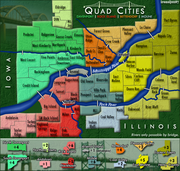
![]() by ironsij0287 on Fri Mar 11, 2011 11:06 am
by ironsij0287 on Fri Mar 11, 2011 11:06 am
-More defined region borders
-Arsenal smoothed out in legend
-Troop numbers at Vandruff to show how they'll fit there
The bridges aren't fancy but they're not destroying the map aesthetics either. I'm leaving them be.
-Arsenal smoothed out in legend
-Troop numbers at Vandruff to show how they'll fit there
The bridges aren't fancy but they're not destroying the map aesthetics either. I'm leaving them be.
- Click image to enlarge.
-
ironsij0287
- Posts: 379
- Joined: Tue Nov 09, 2010 2:30 pm
- Location: Dubuque
Re: Quad Cities Map
![]() by natty dread on Fri Mar 11, 2011 11:12 am
by natty dread on Fri Mar 11, 2011 11:12 am
Or you can change the label on the map to "Vn." and add to the legend an explanation "Vn. = Vandruff". I'm not usually a fan of abbreviations but here I think it might be a good solution, since you can't enlargen the island without also fudging the bordering land areas.
-
natty dread
- Posts: 12877
- Joined: Fri Feb 08, 2008 8:58 pm
- Location: just plain fucked
Re: Quad Cities Map
![]() by natty dread on Fri Mar 11, 2011 11:14 am
by natty dread on Fri Mar 11, 2011 11:14 am
You should at least make the bridges consistent in how much they intrude onto the land. Jefjef has a point there (gasp! the world is going to end now  )
)
-
natty dread
- Posts: 12877
- Joined: Fri Feb 08, 2008 8:58 pm
- Location: just plain fucked
Re: Quad Cities Map
![]() by ironsij0287 on Fri Mar 11, 2011 11:17 am
by ironsij0287 on Fri Mar 11, 2011 11:17 am
Frustration levels are reaching critical levels here.
After all the tweaks, changes and revisions, now the bridges are mentioned? They've literally been the exact same from the very beginning.
I'll go work on them......
After all the tweaks, changes and revisions, now the bridges are mentioned? They've literally been the exact same from the very beginning.
I'll go work on them......
-
ironsij0287
- Posts: 379
- Joined: Tue Nov 09, 2010 2:30 pm
- Location: Dubuque
Re: Quad Cities Map
![]() by natty dread on Fri Mar 11, 2011 11:27 am
by natty dread on Fri Mar 11, 2011 11:27 am
ironsij0287 wrote:Frustration levels are reaching critical levels here.
That's normal. Try not to stress about it.
I swear, with pretty much every map I've made, I've had those moments when I open the thread in the morning, read the new pots and just think "ok f*ck this, I'm gonna bin this piece of crap." But eventually I think, I've come this far, I might as well finish this thing. And so I keep working on it.
I think, that's actually what separates the succesful mapmakers from those who fail: the ability to cope with changes and demands even when they seem frustrating, the ability to just keep on working no matter what, even when you don't feel like it... and yes, mapmaking is fun in general, but there will always be those moments when it is not so fun. You just have to bear it and keep pushing it through.
-
natty dread
- Posts: 12877
- Joined: Fri Feb 08, 2008 8:58 pm
- Location: just plain fucked
Re: Quad Cities Map
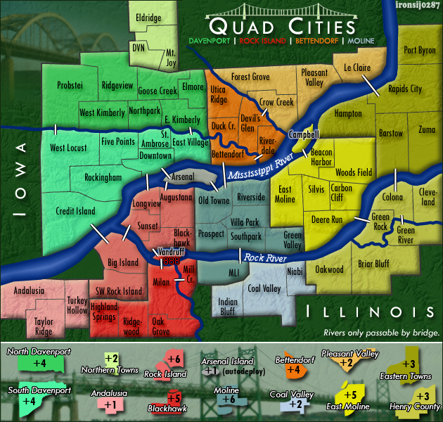
![]() by ironsij0287 on Fri Mar 11, 2011 11:36 am
by ironsij0287 on Fri Mar 11, 2011 11:36 am
plowing through....
- Click image to enlarge.

-
ironsij0287
- Posts: 379
- Joined: Tue Nov 09, 2010 2:30 pm
- Location: Dubuque
Re: Quad Cities Map
![]() by natty dread on Fri Mar 11, 2011 11:44 am
by natty dread on Fri Mar 11, 2011 11:44 am
I'm still not really sure about Vandruff. It would look better if you could fit the number inside the land... Think about abbreviating the territory name.
What I meant about the bridges was, don't just move them, but shorten the ones that are "too long" for the river...
What I meant about the bridges was, don't just move them, but shorten the ones that are "too long" for the river...
-
natty dread
- Posts: 12877
- Joined: Fri Feb 08, 2008 8:58 pm
- Location: just plain fucked
Re: Quad Cities Map
![]() by ironsij0287 on Fri Mar 11, 2011 11:47 am
by ironsij0287 on Fri Mar 11, 2011 11:47 am
natty_dread wrote:I'm still not really sure about Vandruff. It would look better if you could fit the number inside the land... Think about abbreviating the territory name.
What I meant about the bridges was, don't just move them, but shorten the ones that are "too long" for the river...
Oh, I extended the ones that were too short instead.
-
ironsij0287
- Posts: 379
- Joined: Tue Nov 09, 2010 2:30 pm
- Location: Dubuque
Re: Quad Cities Map
![]() by natty dread on Fri Mar 11, 2011 11:50 am
by natty dread on Fri Mar 11, 2011 11:50 am
Yeah... well that could work too if they all would intrude on the land exactly the same amount. But now they seem a little mismatched, kinda like you have blind bridgebuilders who don't know where they should start building...
-
natty dread
- Posts: 12877
- Joined: Fri Feb 08, 2008 8:58 pm
- Location: just plain fucked
Re: Quad Cities Map
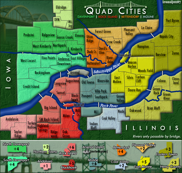
![]() by ironsij0287 on Fri Mar 11, 2011 11:51 am
by ironsij0287 on Fri Mar 11, 2011 11:51 am
- Click image to enlarge.

What about this?
-
ironsij0287
- Posts: 379
- Joined: Tue Nov 09, 2010 2:30 pm
- Location: Dubuque
Re: Quad Cities Map
![]() by ironsij0287 on Fri Mar 11, 2011 11:56 am
by ironsij0287 on Fri Mar 11, 2011 11:56 am
natty_dread wrote:Yeah... well that could work too if they all would intrude on the land exactly the same amount. But now they seem a little mismatched, kinda like you have blind bridgebuilders who don't know where they should start building...
I think this is really splitting hairs here. All the bridges are clearly visible and easily illustrate what territories they connect. Also having them extend inland is more accurate to how they are in real life, especially for the bridges over the Mississippi and Rock Rivers, since they're either quite large or part of a Interstate or freeway that's raised high above the ground already.
-
ironsij0287
- Posts: 379
- Joined: Tue Nov 09, 2010 2:30 pm
- Location: Dubuque
Re: Quad Cities Map
![]() by natty dread on Fri Mar 11, 2011 12:02 pm
by natty dread on Fri Mar 11, 2011 12:02 pm
The Vandruff label: Hm, not bad. Any chance you could widen the river just slightly where the Vandruff label is? Just from the south side should be enough.
Bridges: I understand it may seem like "splitting hairs" but it's the details that are most important, you know? It's ok for the bridges to extend inland, I'm just saying it would be nice if they all would extend the same amount.
I'm not sure what kind of selection tools PS has but in GIMP you can select by alpha channel. So that you could for example select the river area, then expand the selection by 1-2 pixels, invert the selection, go to the bridge layer and erase selection - this way you would cut all the bridges at exactly the same distance from the river.
-
natty dread
- Posts: 12877
- Joined: Fri Feb 08, 2008 8:58 pm
- Location: just plain fucked

Re: Quad Cities Map
![]() by ironsij0287 on Fri Mar 11, 2011 12:21 pm
by ironsij0287 on Fri Mar 11, 2011 12:21 pm
I realize I forgot to fix the bridge between Bettendorf and Moline before I published that last one. It's been fixed.
-
ironsij0287
- Posts: 379
- Joined: Tue Nov 09, 2010 2:30 pm
- Location: Dubuque
Re: Quad Cities Map
![]() by isaiah40 on Fri Mar 11, 2011 1:29 pm
by isaiah40 on Fri Mar 11, 2011 1:29 pm
This is looking better! So, soon and very soon we are going to FF!!  That is as soon as FF gets cleared out a bit.
-
isaiah40
- Posts: 3990
- Joined: Mon Aug 27, 2007 7:14 pm


Re: Quad Cities Map
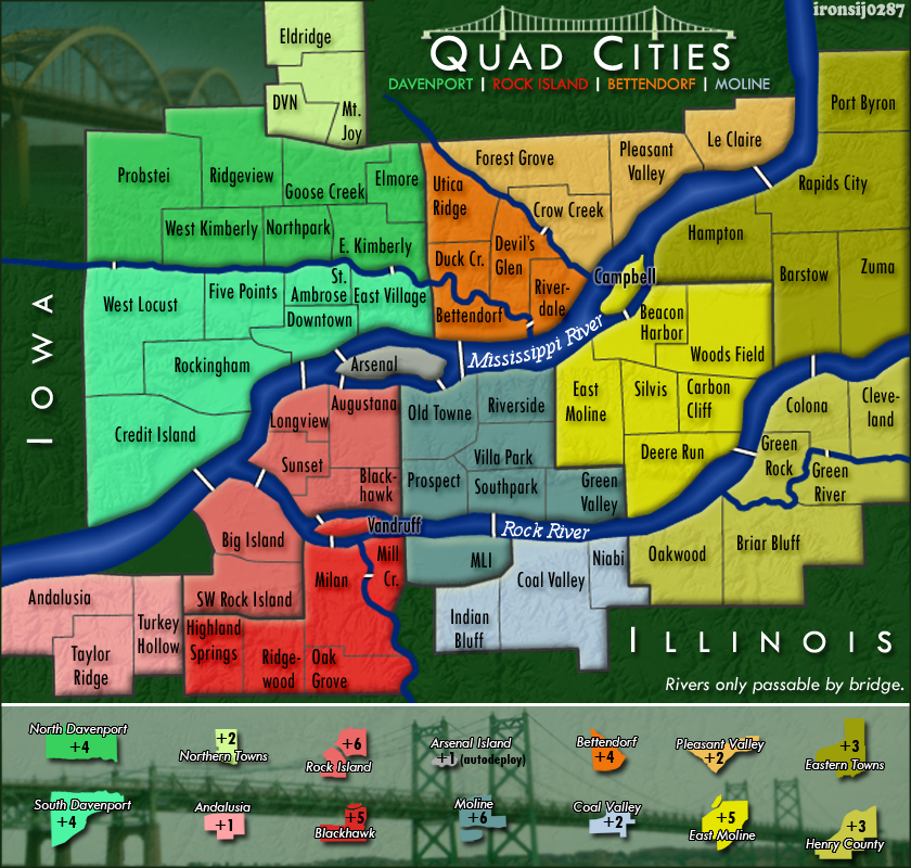
![]() by ironsij0287 on Fri Mar 11, 2011 9:05 pm
by ironsij0287 on Fri Mar 11, 2011 9:05 pm
- Click image to enlarge.
- Click image to enlarge.
-
ironsij0287
- Posts: 379
- Joined: Tue Nov 09, 2010 2:30 pm
- Location: Dubuque
Re: Quad Cities Map
![]() by jefjef on Sat Mar 12, 2011 2:30 am
by jefjef on Sat Mar 12, 2011 2:30 am
Can you bolden/brighten the Green River tert bridge a bit? Probstie looks a bit weak also.
Green Rock bridge looks fuzzy and MLI is crooked.
Green Rock bridge looks fuzzy and MLI is crooked.
This post was made by jefjef who should be on your ignore list.
drunkmonkey wrote:I'm filing a C&A report right now. Its nice because they have a drop-down for "jefjef".
-
jefjef
- Posts: 6026
- Joined: Mon Feb 23, 2009 8:41 pm
- Location: on my ass
Re: Quad Cities Map
![]() by RjBeals on Sat Mar 12, 2011 6:07 pm
by RjBeals on Sat Mar 12, 2011 6:07 pm
i suggest to remove the drop shadow from the territory fonts.
remove the rounded bridge in the top left of the map, keep the terrain map all the way around
also that bridge image in the bottom legend looks bad also. Is there anything else you can do with that?
Looks like "bridges" is the theme of this map so instead of the white lines as bridges, could you try to make cooler bridges?

-

RjBeals
- Posts: 2506
- Joined: Mon Nov 20, 2006 5:17 pm
- Location: South Carolina, USA


Re: Quad Cities Map
![]() by ironsij0287 on Sat Mar 12, 2011 8:16 pm
by ironsij0287 on Sat Mar 12, 2011 8:16 pm
RjBeals wrote:i suggest to remove the drop shadow from the territory fonts.
remove the rounded bridge in the top left of the map, keep the terrain map all the way around
also that bridge image in the bottom legend looks bad also. Is there anything else you can do with that?
Looks like "bridges" is the theme of this map so instead of the white lines as bridges, could you try to make cooler bridges?
Rounded bridge gone, check.
Bottom bridge image - You want me to do some sort of effect on it or something? The image has to remain somewhat muted so the regions stand out over top of it.
Cool bridges - I'm down with this idea but I suck as an artist so drawing my own would probably be bad. Is there any place that has some sort of bridge symbology that I can work with?
-
ironsij0287
- Posts: 379
- Joined: Tue Nov 09, 2010 2:30 pm
- Location: Dubuque
Who is online
Users browsing this forum: No registered users
|
|||||||
| Conquer Club is not associated with RISK online in any way. Copyright © 2006-2025 by Big Wham LLC | |||||||