Netherlands [Quenched]
Moderator: Cartographers
![]() by Lone.prophet on Fri Aug 31, 2007 10:48 am
by Lone.prophet on Fri Aug 31, 2007 10:48 am
thats cause its so bright there it wont come through than

-
 Lone.prophet
- Posts: 1467
- Joined: Thu Oct 12, 2006 4:37 pm
- Location: Your basement Muahaha


![]() by reverend_kyle on Fri Aug 31, 2007 11:07 am
by reverend_kyle on Fri Aug 31, 2007 11:07 am
Lone.prophet wrote:thats cause its so bright there it wont come through than
try using a darken or multiply blend mode.
not guarenteeing it will work, but it's worth tampering with.
DANCING MUSTARD FOR POOP IN '08!
-

reverend_kyle
- Posts: 9250
- Joined: Tue Mar 21, 2006 4:08 pm
- Location: 1000 post club


![]() by Lone.prophet on Fri Aug 31, 2007 11:10 am
by Lone.prophet on Fri Aug 31, 2007 11:10 am
no that doesnt work thnx though 
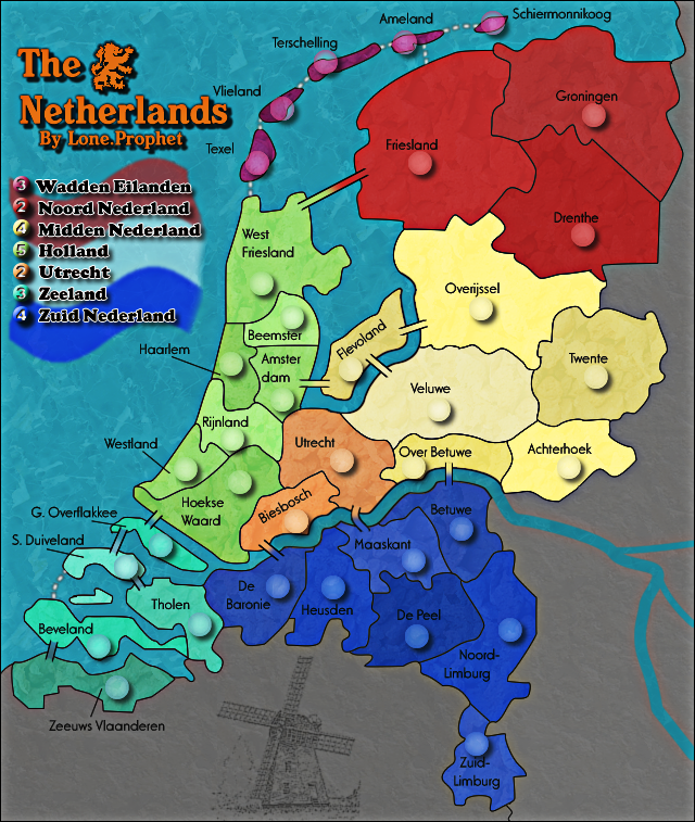
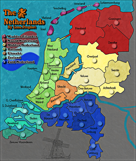
anyway have a new version
with a nice mill and a bit darker color
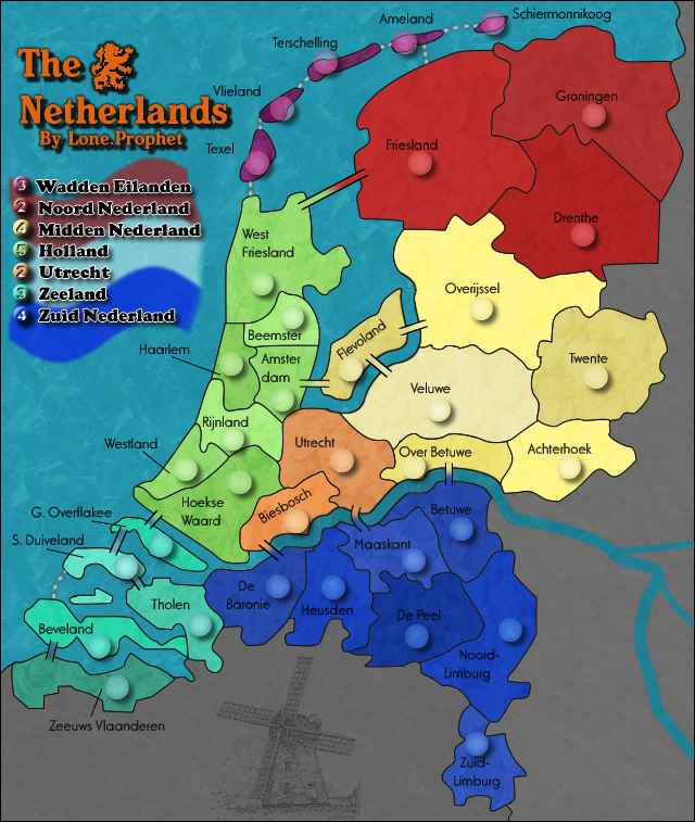
what you think are the colors better or should i change back and does the mill fit?
anyway have a new version
with a nice mill and a bit darker color
what you think are the colors better or should i change back and does the mill fit?
-
Lone.prophet
- Posts: 1467
- Joined: Thu Oct 12, 2006 4:37 pm
- Location: Your basement Muahaha
![]() by unriggable on Fri Aug 31, 2007 11:13 am
by unriggable on Fri Aug 31, 2007 11:13 am
I like the mill, but try to remove the shoadows of the army shadows, its weird.

-

unriggable
- Posts: 8037
- Joined: Thu Feb 08, 2007 9:49 pm


![]() by bonobo`s son on Sun Sep 02, 2007 10:32 am
by bonobo`s son on Sun Sep 02, 2007 10:32 am
i don`tand you should listen to your brotherLone.prophet wrote:i like it


-
bonobo`s son
- Posts: 420
- Joined: Thu Jan 04, 2007 11:27 am
- Location: Amsterdam - Artis


![]() by reverend_kyle on Sun Sep 02, 2007 2:25 pm
by reverend_kyle on Sun Sep 02, 2007 2:25 pm
I don't like the shadow either.
The windmill looks good.
I think you should experiment with making the whole continent roughly one color as most maps do that it seems.
The textures show through nicely now..
Your water texture could be more wavy.
The windmill looks good.
I think you should experiment with making the whole continent roughly one color as most maps do that it seems.
The textures show through nicely now..
Your water texture could be more wavy.
DANCING MUSTARD FOR POOP IN '08!
-
reverend_kyle
- Posts: 9250
- Joined: Tue Mar 21, 2006 4:08 pm
- Location: 1000 post club


![]() by jako on Fri Sep 14, 2007 9:33 am
by jako on Fri Sep 14, 2007 9:33 am
oaktown wrote:first time I've looked at this map in probably six months... am I the only one who can't figure out where the seventh bonus region is?
i think u just miscounted, cause i see 7 bonus regions.

Time to retire this much loved sig of mine with a new clan.
-

jako
- Posts: 1022
- Joined: Sun Jun 03, 2007 4:50 am
- Location: A lost soul with no-one to stalk.


![]() by oaktown on Fri Sep 14, 2007 8:42 pm
by oaktown on Fri Sep 14, 2007 8:42 pm
jako wrote:oaktown wrote:first time I've looked at this map in probably six months... am I the only one who can't figure out where the seventh bonus region is?
i think u just miscounted, cause i see 7 bonus regions.
It's my eyes then, because I can only find six... am I the only color-blind player in the Foundry?

-
oaktown
- Posts: 4451
- Joined: Sun Dec 03, 2006 9:24 pm
- Location: majorcommand


![]() by oaktown on Fri Sep 14, 2007 8:53 pm
by oaktown on Fri Sep 14, 2007 8:53 pm
Gozar wrote:Is it the five islands at the very top that you are missing, oaktown?
Nope, I picked those out just fine... I can't say for sure, but my guess base on the bonus structure is that the Utrecht region is blending in with all the zones around it... and I don't know what Veluwe is supposed to be a part of.. is it neutral?
Thank heavens for the greasemonkey script... without Bob I wouldn't be able to play this map.
-
oaktown
- Posts: 4451
- Joined: Sun Dec 03, 2006 9:24 pm
- Location: majorcommand
![]() by Gozar on Fri Sep 14, 2007 8:55 pm
by Gozar on Fri Sep 14, 2007 8:55 pm
oaktown wrote:Gozar wrote:Is it the five islands at the very top that you are missing, oaktown?
Nope, I picked those out just fine... I can't say for sure, but my guess base on the bonus structure is that the Utrecht region is blending in with all the zones around it... and I don't know what Veluwe is supposed to be a part of.. is it neutral?
Thank heavens for the greasemonkey script... without Bob I wouldn't be able to play this map.
Ah! Utrecht and Biesboch are their own continent. Everything east of there is a separate one.

-

Gozar
- Posts: 2534
- Joined: Wed Jan 31, 2007 3:15 pm
- Location: Nova Scotia (G1)


![]() by cairnswk on Wed Sep 19, 2007 2:14 am
by cairnswk on Wed Sep 19, 2007 2:14 am
lone.prophet...hi...this is the first time i've looked at this map...been kinda busy!
It is looking great and i like the style...however some things concern me....
* could you be so kind to advise if you are still running the poll, it is set to run forever....if you are going to continue it, please post the images for the bridge choices on page 64 or therabouts so people can vote and not have to troll back so far through pages that are hidden behind the dots... i would like to have a say and vote unless this issue is finalised.
* also i am very conscious of the fact that map developers should take into consideration some issue surrounding the colour choices made for the colour blind after this issue was raised in several of my maps. have you checked these colours on your map with any of those palettes for the colour blind....some of the colours from the northern regions come very close to being almost the same.
* don't be offended by this question; the colours in the flag...are they correct...or is that a very dark tone of red used deliberate...i ask this because i think the dark red on the flag clashes severaly with the reds in the legend.
From http://www.crwflags.com/fotw/flags/nl.html
could you have a look at this please, and let me know your decision...as i feel the top "red" is not correct, and i will stand corrected if necessary.
It is looking great and i like the style...however some things concern me....
* could you be so kind to advise if you are still running the poll, it is set to run forever....if you are going to continue it, please post the images for the bridge choices on page 64 or therabouts so people can vote and not have to troll back so far through pages that are hidden behind the dots...
* also i am very conscious of the fact that map developers should take into consideration some issue surrounding the colour choices made for the colour blind after this issue was raised in several of my maps. have you checked these colours on your map with any of those palettes for the colour blind....some of the colours from the northern regions come very close to being almost the same.
* don't be offended by this question; the colours in the flag...are they correct...or is that a very dark tone of red used deliberate...i ask this because i think the dark red on the flag clashes severaly with the reds in the legend.
From http://www.crwflags.com/fotw/flags/nl.html
On 19 February 1937 Queen Wilhelmina decided by Order in council that: "The colours of the flag of the Kingdom of the Netherlands are red, white and blue." In 1958 the colours were defined more precisely as bright vermilion and cobalt blue.
Source: Nederlands vlaggenboek: Vlaggen van Nederland, provincies en gemeenten [sie62].
could you have a look at this please, and let me know your decision...as i feel the top "red" is not correct, and i will stand corrected if necessary.

* Pearl Harbour * Waterloo * Forbidden City * Jamaica * Pot Mosbi
-

cairnswk
- Posts: 11510
- Joined: Sat Feb 03, 2007 8:32 pm
- Location: Australia


![]() by lt_oddball on Wed Oct 03, 2007 12:26 pm
by lt_oddball on Wed Oct 03, 2007 12:26 pm
Well, I notice you didnot do anything with my good suggestion to focus on a Netherlands map of the 1670's (battles with france, england, german bishops, Austrian Habsburgs, Spanish).
Now it (still) looks an AWFUL LOT like the existing Benelux map.
Worse still: the sections in non realistic provinces is also VERY SIMILAR.
Why the hell is Zuid-Holland vivisected in many small parts, but North Holland isn't ?
Why is Utrecht even more split up, and Friesland ITSELF is part of a monstrosity up north ????
Why dont you have a separate Brabant and Limburg provinces ??
Why-why ?
Despite the nice coulours, you didnot give much effort into mapmaking.
Be it for the realism, or be it for improving playability/balance of gameplay.
"onvoldoende"
-

lt_oddball
- Posts: 364
- Joined: Mon Mar 05, 2007 11:17 am
- Location: Fortress Europe
![]() by Coleman on Fri Oct 05, 2007 1:05 pm
by Coleman on Fri Oct 05, 2007 1:05 pm
I think you may need a blur on a lot of the small map borders. They look scratchy, for lack of a better word coming to mind for me at the moment.
Warning: You may be reading a really old topic.
-

Coleman
- Posts: 5402
- Joined: Tue Jan 02, 2007 10:36 pm
- Location: Midwest


![]() by MarVal on Tue Oct 09, 2007 1:42 pm
by MarVal on Tue Oct 09, 2007 1:42 pm
Hallo Lone, first of all great map. I like it at the beginning. Can't wait enough to play someday on it.
And what about the words of Coleman:
Hij bedoelt dat bijvoorbeeld de grenslijn tussen Overijssel en Drenthe happert oftewel de grenslijn is niet een vloeiende lijn, maar op het oog lijkt het of er in deze lijn happeringen in zitten (hapjes eruit).
Ik hoop dat je nu een beetje weet waar ze het over hebben. Maar in een woord, mooie Hollandse map
Above just the Dutch translate for Lone about the "blur". and the best wishes for his map.
Grtz
MarVal
 highest score: 2157 (Major) / Verd ori'shya beskar'gam

-
MarVal
- Posts: 3823
- Joined: Sat Nov 11, 2006 4:45 pm
- Location: De Veroveraars der Lage Landen


Who is online
Users browsing this forum: No registered users
|
|||||||
| Conquer Club is not associated with RISK online in any way. Copyright © 2006-2025 by Big Wham LLC | |||||||