The Cold War (Global Map)
Moderator: Cartographers
64 posts
• Page 3 of 3 • 1, 2, 3
Re: The Cold War (Global Map)
![]() by CptJMoney on Sat Mar 12, 2011 10:19 am
by CptJMoney on Sat Mar 12, 2011 10:19 am
Why is the map all warped? Can't it be a regular square?
-

 CptJMoney
- Posts: 50
- Joined: Thu Jan 20, 2011 7:14 pm
- Location: Atlanta, GA, USA


Re: The Cold War (Global Map)
![]() by murdocho on Sat Mar 12, 2011 11:37 pm
by murdocho on Sat Mar 12, 2011 11:37 pm
Hey guys, super excited to see a Cold-War themed map-- thanks for doing this.
However, I feel obligated to butt in about one thing.
What about the Sino-Soviet rift ??? The Soviets and the Chinese were by no means some communist monolith. There was a pretty heavy falling out in the late 50s-early 60s, and some serious competition followed, including actual fighting along the border. Although rarely mentioned, the Sino-Soviet split was a pretty significant element of the Cold War.
I know you don't want to make the map too complicated, but has anyone considered factoring the split with separate China bonuses and objectives? What I'm thinking is color China completely differently and create a bonus for holding just China, to simulate independent Chinese foreign policy; a bonus for China and USSR, to simulate if the split hadn't of happened; and a large bonus for control of US and China, to simulate what a tremendous advantage it would have been if the US had exploited the rift, or won China over earlier, so to speak.
You could go farther with objectives for influence in the third world... but maybe that would be better for another map...
Anyways, sorry to speak up so late. I just saw this thread and as a Cold War history nut I had to say something.
-
murdocho
- Posts: 3
- Joined: Tue Jan 04, 2011 7:38 am
Re: The Cold War (Global Map)
![]() by Teflon Kris on Sun Mar 13, 2011 5:58 am
by Teflon Kris on Sun Mar 13, 2011 5:58 am
natty_dread wrote:Can't see image.
Hopefully you can now - having some troubles with my connection so could only upload a seriously compressed image in the end.
CptJMoney wrote:Why is the map all warped? Can't it be a regular square?
Yeah - I think it will be - I was aiming for a warped TV-screen-styled map at one point - as if the map were on a superpowers' monitor. However, that wont really work with the inset, so I will revert back to square for the next version.
This version was mainly about getting the Europe inset right ... square update coming soon. I'm also wondering if a central america inset might be better than trying to increase its size?
murdocho wrote:What about the Sino-Soviet rift ??? The Soviets and the Chinese were by no means some communist monolith. There was a pretty heavy falling out in the late 50s-early 60s, and some serious competition followed, including actual fighting along the border. Although rarely mentioned, the Sino-Soviet split was a pretty significant element of the Cold War.
I know you don't want to make the map too complicated, but has anyone considered factoring the split with separate China bonuses and objectives? What I'm thinking is color China completely differently and create a bonus for holding just China, to simulate independent Chinese foreign policy; a bonus for China and USSR, to simulate if the split hadn't of happened; and a large bonus for control of US and China, to simulate what a tremendous advantage it would have been if the US had exploited the rift, or won China over earlier, so to speak.
You could go farther with objectives for influence in the third world... but maybe that would be better for another map..
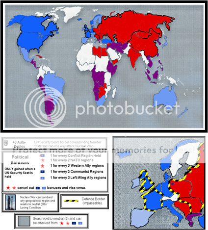
Something to think about certainly. I'm just thinking that gameplay-wise it may work better to consider the left all-together as much as possible, to create a balance and equal value for players to focus on one (the left) or the other (NATO & allies). This also applies to regions where there was a soviet/chinese/left-wing influence/administration at some point during the cold war so that we get enough red and light-red regions for the bonus system to work (in comparison to blue and light-blue regions). So, nations that reverted from left-to-right are taken as left - kind of artistic licence for gameplay purposes.
With the gameplay as it is, there isn't much extra advantage to holding both China and USSR, just as there isn't much extra advantage in holding the UK and USA. Just holdng one superpower on either side opens up the bonuses. Players then need to battle out in the southern(& central) continents. Holding a superpower on both sides would be more advantageous than several on one side (as the gameplay stands currently, unless it is decided that bonuses should double-up with more superpowers, which would be contrary to your point).
-

Teflon Kris
- Posts: 4236
- Joined: Sun Jul 13, 2008 4:39 pm
- Location: Lancashire, United Kingdom


Re: The Cold War (Global Map)
![]() by isaiah40 on Mon Mar 28, 2011 4:41 pm
by isaiah40 on Mon Mar 28, 2011 4:41 pm
DJ Teflon wrote:Yeah - I think it will be - I was aiming for a warped TV-screen-styled map at one point - as if the map were on a superpowers' monitor. However, that wont really work with the inset, so I will revert back to square for the next version.
This version was mainly about getting the Europe inset right ... square update coming soon. I'm also wondering if a central america inset might be better than trying to increase its size?
I'm wondering if this would do better if it was supersized a bit

If you do the supersize map, then you could do the insets as TV monitors as well. Maybe like a bank of monitors, to monitor different areas of the globe, IDK but it might work.
-
isaiah40
- Posts: 3990
- Joined: Mon Aug 27, 2007 7:14 pm


Re: The Cold War (Global Map)
![]() by Teflon Kris on Tue Mar 29, 2011 4:27 am
by Teflon Kris on Tue Mar 29, 2011 4:27 am
isaiah40 wrote:DJ Teflon wrote:Yeah - I think it will be - I was aiming for a warped TV-screen-styled map at one point - as if the map were on a superpowers' monitor. However, that wont really work with the inset, so I will revert back to square for the next version.
This version was mainly about getting the Europe inset right ... square update coming soon. I'm also wondering if a central america inset might be better than trying to increase its size?
I'm wondering if this would do better if it was supersized a bit
If you do the supersize map, then you could do the insets as TV monitors as well. Maybe like a bank of monitors, to monitor different areas of the globe, IDK but it might work.
That was my idea with the monitors - somehow a large monitor for the main map, smaller monitors below for the Europe inset and legend, and maybe Central America?
Last edited by Teflon Kris on Tue Mar 29, 2011 5:29 am, edited 1 time in total.
-
Teflon Kris
- Posts: 4236
- Joined: Sun Jul 13, 2008 4:39 pm
- Location: Lancashire, United Kingdom
Re: The Cold War (Global Map)
![]() by natty dread on Tue Mar 29, 2011 5:11 am
by natty dread on Tue Mar 29, 2011 5:11 am
I think supersize would be good for this map. In fact I think it'd be pretty much necessary.

-

natty dread
- Posts: 12877
- Joined: Fri Feb 08, 2008 8:58 pm
- Location: just plain fucked


Re: The Cold War (Global Map)
![]() by isaiah40 on Thu Mar 31, 2011 8:25 pm
by isaiah40 on Thu Mar 31, 2011 8:25 pm
DJ Teflon wrote:That was my idea with the monitors - somehow a large monitor for the main map, smaller monitors below for the Europe inset and legend, and maybe Central America?
Yea, that's what I'd go with. and as natty said:
natty_dread wrote:I think supersize would be good for this map. In fact I think it'd be pretty much necessary.
This way everything would fit in nicely. Submit a request for supersize! I'd really like to see this map continued.
-
isaiah40
- Posts: 3990
- Joined: Mon Aug 27, 2007 7:14 pm
Re: The Cold War (Global Map)
![]() by Teflon Kris on Sun Apr 03, 2011 10:56 am
by Teflon Kris on Sun Apr 03, 2011 10:56 am
Ok folks
I will work on a standard-style map a touch more in the first instance - put in region names etc.
Then I will see about the monitors The only problem is that one large and two small monitors would be ideal, however, we may need 3 small monitors ((1) Europe; (2) Central America; (3) The 'legend' + UN seats /nuke war monitor - Unless 2 & 3 can be combined with some 'legend ' stuff on each monitor ("Intelligence" read-out at the bottom)). This will take some time but is worth doing - until I have done it will be hard to guess what kind of size will be required, so I'll work on it before the request.
Before any of this, I have some diagrams to draw for the W Cities contest, so I will be back here mid-week.

I will work on a standard-style map a touch more in the first instance - put in region names etc.
Then I will see about the monitors
Before any of this, I have some diagrams to draw for the W Cities contest, so I will be back here mid-week.
-
Teflon Kris
- Posts: 4236
- Joined: Sun Jul 13, 2008 4:39 pm
- Location: Lancashire, United Kingdom
Re: The Cold War (Global Map)
![]() by thenobodies80 on Sat May 07, 2011 5:04 pm
by thenobodies80 on Sat May 07, 2011 5:04 pm
If you ask to me I prefer this layout DJ
- Click image to enlarge.
-

thenobodies80
- Posts: 5399
- Joined: Wed Sep 05, 2007 4:30 am
- Location: Milan


Re: The Cold War (Global Map)
![]() by MrBenn on Sun Jun 26, 2011 4:49 pm
by MrBenn on Sun Jun 26, 2011 4:49 pm
[Moved]
It would appear that development of this map has stalled. If the mapmaker wants to continue with the map, then one of the Foundry Moderators will be able to help put the thread back into the Foundry system, after an update has been made.
It would appear that development of this map has stalled. If the mapmaker wants to continue with the map, then one of the Foundry Moderators will be able to help put the thread back into the Foundry system, after an update has been made.

PB: 2661 | He's blue... If he were green he would die | No mod would be stupid enough to do that
-

MrBenn
- Posts: 6880
- Joined: Wed Nov 21, 2007 9:32 am
- Location: Off Duty


Re: The Cold War (Global Map)
![]() by ViperOverLord on Mon Jan 16, 2012 9:32 am
by ViperOverLord on Mon Jan 16, 2012 9:32 am
A couple things I see missing at a glance:
- Spy planes
- Nuclear submarines
- Focus on key cold war strategy points - Cuba/Poland missle bases, Eastern bloc, Berlin Wall, Key allies and of course a real focus on USA vs. USSR
- Spy planes
- Nuclear submarines
- Focus on key cold war strategy points - Cuba/Poland missle bases, Eastern bloc, Berlin Wall, Key allies and of course a real focus on USA vs. USSR
-

ViperOverLord
- Posts: 2444
- Joined: Sun Apr 19, 2009 3:19 pm
- Location: California


Re: The Cold War (Global Map)
![]() by Teflon Kris on Sat Aug 02, 2014 1:21 pm
by Teflon Kris on Sat Aug 02, 2014 1:21 pm
This idea could be developed using new features:
Instead, there could also be a 'Peacemakers' region, which cannot be attacked by a player holding Nuclear War and visa-versa (conditional borders), and, a decay on all geographic regions at start of turn by any player holding nuclear war (conditional decay assuming this is possible)? Rather than nuclear war being a total losing condition, it would be a major disadvantage instead (to a player that invokes it but fails to win on first strike).
Also, the map graphics could change slightly to give a nuclear war theme, once Nuclear War is taken by any player?
There's one element that I'm thinking might be really interesting to add in, that being Nuclear War. Make it border from the UN security Council and bombard every territory. Think of it as a player able to go from Soviet Union to their council seat to nuke war. BUT, if Nuke war is held then the player loses by losing conditions.
Instead, there could also be a 'Peacemakers' region, which cannot be attacked by a player holding Nuclear War and visa-versa (conditional borders), and, a decay on all geographic regions at start of turn by any player holding nuclear war (conditional decay assuming this is possible)? Rather than nuclear war being a total losing condition, it would be a major disadvantage instead (to a player that invokes it but fails to win on first strike).
Also, the map graphics could change slightly to give a nuclear war theme, once Nuclear War is taken by any player?
-
Teflon Kris
- Posts: 4236
- Joined: Sun Jul 13, 2008 4:39 pm
- Location: Lancashire, United Kingdom
Re: The Cold War (Global Map)
![]() by Teflon Kris on Sat Aug 02, 2014 1:25 pm
by Teflon Kris on Sat Aug 02, 2014 1:25 pm
thenobodies80 wrote:If you ask to me I prefer this layout DJ
- Click image to enlarge.
Yeah - this layout with bottom part of main globe squashed and 3 TV screens.
Major graphics help needed though
-
Teflon Kris
- Posts: 4236
- Joined: Sun Jul 13, 2008 4:39 pm
- Location: Lancashire, United Kingdom
64 posts
• Page 3 of 3 • 1, 2, 3
Return to Melting Pot: Map Ideas
Who is online
Users browsing this forum: No registered users
|
|||||||
| Conquer Club is not associated with RISK online in any way. Copyright © 2006-2024 by Big Wham LLC | |||||||