The American Revolutionary War [vacation]
Moderator: Cartographers
116 posts
• Page 2 of 5 • 1, 2, 3, 4, 5
![]() by Gnome on Wed Oct 17, 2007 10:47 am
by Gnome on Wed Oct 17, 2007 10:47 am
DiM wrote:what's the font in the legend? i love it.
It's called "bleeding Cowboy"
muy_thaiguy wrote:You should include Spain, they helped in the South quite a bit (they also had control of Florida).
On the map I use they didn't...Spain was in control of Louisiana
http://en.wikipedia.org/wiki/Image:British_colonies_1763-76_shepherd1923.jpg
I GOT SERVED wrote:The only issue I have is that how are you going to fit army numbers in territories like New Jersey, Delaware, Connecticut and RI? They seem really small. Maybe you could merge New Jersey and Delaware, and merge Connecticut and RI. That might give you some extra wiggle room for army numbers
I don't know if I can keep it like this...maybe I will have to but I think the army circles fit...but names not
bryguy wrote:ooks a lot better, thanks for adding Rhode island. the only thing that i can see that is really off is that Pennsylvania is to small in the top left corner
you sure? when I look at this maps it seems that the borders are more straight than on my map but I don't think it's that bad...

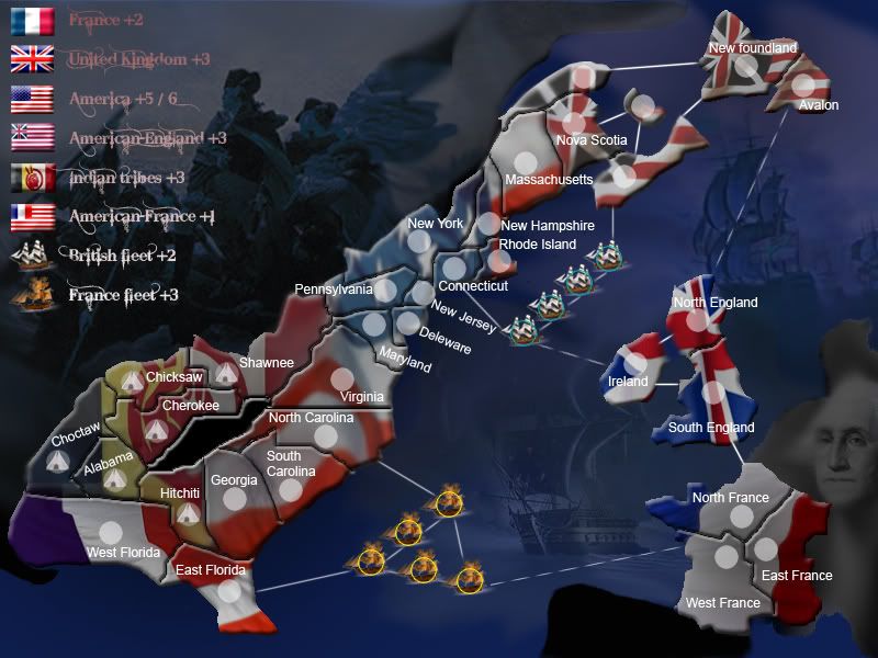
Version 6.0
details:
-added army circles
-added names (correct me if I'm wrong)
Needs:
-Can some1 tell how I should call the territories of American England?
-Should I give boats a name or just a number?
-anything that bothers you

-

 Gnome
Gnome
- Posts: 388
- Joined: Wed Jul 18, 2007 4:15 am
- Location: Belgium


![]() by bryguy on Wed Oct 17, 2007 11:27 am
by bryguy on Wed Oct 17, 2007 11:27 am
Gnome wrote:DiM wrote:what's the font in the legend? i love it.
It's called "bleeding Cowboy"muy_thaiguy wrote:You should include Spain, they helped in the South quite a bit (they also had control of Florida).
On the map I use they didn't...Spain was in control of Louisiana
http://en.wikipedia.org/wiki/Image:British_colonies_1763-76_shepherd1923.jpgI GOT SERVED wrote:The only issue I have is that how are you going to fit army numbers in territories like New Jersey, Delaware, Connecticut and RI? They seem really small. Maybe you could merge New Jersey and Delaware, and merge Connecticut and RI. That might give you some extra wiggle room for army numbers
I don't know if I can keep it like this...maybe I will have to but I think the army circles fit...but names not bryguy wrote:ooks a lot better, thanks for adding Rhode island. the only thing that i can see that is really off is that Pennsylvania is to small in the top left corner
you sure? when I look at this maps it seems that the borders are more straight than on my map but I don't think it's that bad...
Version 6.0
details:
-added army circles
-added names (correct me if I'm wrong)
Needs:
-Can some1 tell how I should call the territories of American England?
-Should I give boats a name or just a number?
-anything that bothers you
i think u should give boats numbers, like f1, f2, and e1, e2
oh and your right, i was just looking at pennsylvania wrong (i was looking at new york actually lol). and what do u mean by "can some1 tell me how i should call the territories of american england?" i dont get that. oh wait now i see it now, ill look into it
-
bryguy
- Posts: 4381
- Joined: Tue Aug 07, 2007 8:50 am
- Location: Lost in a Jigsaw


![]() by bryguy on Wed Oct 17, 2007 11:31 am
by bryguy on Wed Oct 17, 2007 11:31 am
ok, the little iladn off of nova scotia was called Prince Edward Island, and that spot that u can get to by nova, one ship, new foundland, and Edward Island was actually part of nova scotia, and that last spot (the one that u can get to by newfoundland and nova and massachusetts is actually part of the quebec province, which is part of france. So u might want to take that out, but ill let u know if i find a specific name for it
-
bryguy
- Posts: 4381
- Joined: Tue Aug 07, 2007 8:50 am
- Location: Lost in a Jigsaw


![]() by Coleman on Wed Oct 17, 2007 3:48 pm
by Coleman on Wed Oct 17, 2007 3:48 pm
Some territories are still missing names, which is part of the laundry list of requirements. So no moving yet from my perspective.
This is what I use, derived from the sticky topic:
At current at least three British American territory names are missing and all fleet names are missing. Once they have names we can move this.
This is what I use, derived from the sticky topic:
Coleman wrote:A. Some sort of clear plan of how production will go.
B. the map must have a working image (either of the small or large map). This working image must be beyond the ‘rough draft’ state. I.E. the working image can’t be a pencil/paper drawing or an MS paint image. To Elaborate:
* Include a working legend with speculative bonuses
* tentative border divisions
* names
* barriers
* colors and textures
* aesthetic images (I.E. compasses, picture designs, etc)
* background image (I.E. ocean or something to discriminate the playing field)
* A map should be ‘inherently unique either in game play, location, or style’ . Maps that aren't just the same tried and true formula from the Classic Map disguised will be more successful.
* Every effort should be made to acquire express written consent for a map based on Copyrighted works. In the event that no response is given by the Copyright holders, the map can still be made, but must consist of completely original artwork.
C. the map (or the post) must also include a few basic things for easy reference such as:
* number of countries currently on the map & number of continents
* descriptions of any unique features or areas
* the title of the map must indicate the page with the latest development of production (I.E. ‘Update – Pg 3, and please, no use of [brackets]: use (parentheses), --dashes--, or “quotes”)
D. the map must have some honest and interested discussion. If no one seems to support your idea or it lacks much appeal, it most likely won’t make it to the next stage.
At current at least three British American territory names are missing and all fleet names are missing. Once they have names we can move this.
Last edited by Coleman on Wed Oct 17, 2007 3:53 pm, edited 1 time in total.
Warning: You may be reading a really old topic.
-

Coleman
- Posts: 5402
- Joined: Tue Jan 02, 2007 10:36 pm
- Location: Midwest


![]() by ps2civxr20 on Wed Oct 17, 2007 4:45 pm
by ps2civxr20 on Wed Oct 17, 2007 4:45 pm
the french didnt own florida the british did. all the french owned in america at this point was haiti. I think you should change french americas name to british florida and change its background
-
ps2civxr20
- Posts: 49
- Joined: Tue Sep 11, 2007 5:21 pm
![]() by Gnome on Wed Oct 17, 2007 4:49 pm
by Gnome on Wed Oct 17, 2007 4:49 pm
ps2civxr20 wrote:the french didnt own florida the british did. all the french owned in america at this point was haiti. I think you should change french americas name to british florida and change its background
But than why is france on this map...I'm sure france had to do something with this war
-
Gnome
- Posts: 388
- Joined: Wed Jul 18, 2007 4:15 am
- Location: Belgium
![]() by bryguy on Wed Oct 17, 2007 5:25 pm
by bryguy on Wed Oct 17, 2007 5:25 pm
ps2civxr20 wrote:the french didnt own florida the british did. all the french owned in america at this point was haiti. I think you should change french americas name to british florida and change its background
wrong, spain had florida
-
bryguy
- Posts: 4381
- Joined: Tue Aug 07, 2007 8:50 am
- Location: Lost in a Jigsaw
![]() by bryguy on Wed Oct 17, 2007 5:26 pm
by bryguy on Wed Oct 17, 2007 5:26 pm
Gnome wrote:ps2civxr20 wrote:the french didnt own florida the british did. all the french owned in america at this point was haiti. I think you should change french americas name to british florida and change its background
But than why is france on this map...I'm sure france had to do something with this war
it did, it helped with defeating the british navy, and did a big part in taking back new york, but just leave that as it is, since u dont have spain in it.
-
bryguy
- Posts: 4381
- Joined: Tue Aug 07, 2007 8:50 am
- Location: Lost in a Jigsaw
![]() by muy_thaiguy on Wed Oct 17, 2007 5:28 pm
by muy_thaiguy on Wed Oct 17, 2007 5:28 pm
Ever heard of the Louisiana Purchase? A big territory purchased by Thomas Jefferson from Napolean Bonaparte in 1802 or 1803 I think. Ans Spain DID have control of Florida.ps2civxr20 wrote:the french didnt own florida the british did. all the french owned in america at this point was haiti. I think you should change french americas name to british florida and change its background
"Eh, whatever."
-Anonymous
What, you expected something deep or flashy?
-Anonymous
What, you expected something deep or flashy?
-

muy_thaiguy
- Posts: 12727
- Joined: Fri May 18, 2007 11:20 am
- Location: Back in Black


![]() by ps2civxr20 on Wed Oct 17, 2007 5:43 pm
by ps2civxr20 on Wed Oct 17, 2007 5:43 pm
florida was spanish but was given to britain as a result of the 7 years war (French indian war in the us) and was given back after the revolution because spain took part in it. Also louisiana was givin to spain by france because france got spain into the 7 years war but it was secretly given back to france during the nepolionic era. So we bought it.
-
ps2civxr20
- Posts: 49
- Joined: Tue Sep 11, 2007 5:21 pm
![]() by bryguy on Wed Oct 17, 2007 5:50 pm
by bryguy on Wed Oct 17, 2007 5:50 pm
ps2civxr20 wrote:florida was spanish but was given to britain as a result of the 7 years war (French indian war in the us) and was given back after the revolution because spain took part in it. Also louisiana was givin to spain by france because france got spain into the 7 years war but it was secretly given back to france during the nepolionic era. So we bought it.
ok now i know that aint right, spain didnt do anything in the revolution, didnt do anything in the french india war, and louisiana is kind of hard to give to spain from france if lousiana was controlled by england.
-
bryguy
- Posts: 4381
- Joined: Tue Aug 07, 2007 8:50 am
- Location: Lost in a Jigsaw
![]() by ps2civxr20 on Wed Oct 17, 2007 5:53 pm
by ps2civxr20 on Wed Oct 17, 2007 5:53 pm
or we could all just look it up
http://en.wikipedia.org/wiki/7_years_war#Peace
this wasnt the first place i learned what i knew
http://en.wikipedia.org/wiki/7_years_war#Peace
this wasnt the first place i learned what i knew
-
ps2civxr20
- Posts: 49
- Joined: Tue Sep 11, 2007 5:21 pm
![]() by bryguy on Wed Oct 17, 2007 6:38 pm
by bryguy on Wed Oct 17, 2007 6:38 pm
ps2civxr20 wrote:or we could all just look it up
http://en.wikipedia.org/wiki/7_years_war#Peace
this wasnt the first place i learned what i knew
ive already read it
-
bryguy
- Posts: 4381
- Joined: Tue Aug 07, 2007 8:50 am
- Location: Lost in a Jigsaw
![]() by Coleman on Wed Oct 17, 2007 10:57 pm
by Coleman on Wed Oct 17, 2007 10:57 pm
I'm not sure this debate is helpful. This is supposed to be revolutionary war map. The southern area is being referred to as French-America for convenience as a continent devision, not necessarily historical accuracy.
Warning: You may be reading a really old topic.
-
Coleman
- Posts: 5402
- Joined: Tue Jan 02, 2007 10:36 pm
- Location: Midwest
![]() by bryguy on Fri Oct 19, 2007 7:02 am
by bryguy on Fri Oct 19, 2007 7:02 am
Coleman wrote:I'm not sure this debate is helpful. This is supposed to be revolutionary war map. The southern area is being referred to as French-America for convenience as a continent devision, not necessarily historical accuracy.
ty, i was going to say that
-
bryguy
- Posts: 4381
- Joined: Tue Aug 07, 2007 8:50 am
- Location: Lost in a Jigsaw
![]() by Gnome on Fri Oct 19, 2007 12:07 pm
by Gnome on Fri Oct 19, 2007 12:07 pm
alright, got some name changes
here are my sources
nova scotia

gaspe coast

version 7.0

comments welcome
here are my sources
nova scotia
gaspe coast
La Gaspésie ou communément appelée Gaspé par les anglophones (en anglais Gaspe coast) est la région du Québec qui couvre, en tout ou en partie, la péninsule gaspésienne située à l'extrême est du Canada, près du golfe du Saint-Laurent.
version 7.0
comments welcome
-
Gnome
- Posts: 388
- Joined: Wed Jul 18, 2007 4:15 am
- Location: Belgium
116 posts
• Page 2 of 5 • 1, 2, 3, 4, 5
Return to Melting Pot: Map Ideas
Who is online
Users browsing this forum: No registered users
|
|||||||
| Conquer Club is not associated with RISK online in any way. Copyright © 2006-2025 by Big Wham LLC | |||||||