I personally dont like the growing trend in the foundry of making maps of small insignificant areas (theres not even a city with over 1 million people, reminds me of that belgium state map, fleance or something).
Most of the criticisms i can come up with have already been said. Will need alot of work.
To Marvaddin: I like Indochina, its a nice clean map.
Wisconsin Map Revealed!
Moderator: Cartographers
Forum rules
Please read the Community Guidelines before posting.
Please read the Community Guidelines before posting.
-
gavin_sidhu

- Posts: 1428
- Joined: Mon May 22, 2006 6:16 am
- Location: Brisbane, Australia
-
happysadfun

- Posts: 1251
- Joined: Mon Jul 10, 2006 9:06 pm
- Location: Haundin at DotSco, Being Sad that Mark Green Lost in Suburban Wisconsin


AndyDufresne wrote:It will be one of the first to test the more than standard countries. Obviously tests should be done before hand, before creating a great map, and then having it be unplayable.
--Andy
Respectfully disagree on this one, Andy. Testing just isn't practical for most people, and I think the "results" of this sort of test are going to be very subjective anyway. Plunge, folks.
hotgun wrote:What on earth... why is this getting so much good feedback and helpful!... where were these people when me and cybertech were making the MN map... this is a state 2!, why is this getting better feedback than ours did... no one wanted ours so we didn't finish making it after all the work we did!
There are a lot more users on this site now than when you were working on the Minnesota map. I think that has a lot to do with it.


spiesr wrote:Save yourself a wasted lifetime and stop now...
Wow. You're an ass, huh?
Listen man, if you want to make a Wisconsin map, it can certainly be done. Just take the advice that has been offered to you - it won't be "accurate" by individual counties. You'll need to combine some, and perhaps "explode" the different regions so they only intersect at certain points.
It can be done, it'll just take work. Good luck.


-
dcowboys055

- Posts: 2341
- Joined: Wed Apr 26, 2006 7:32 pm
- Gender: Male
- Location: Milwaukee
-
DublinDoogey

- Posts: 329
- Joined: Tue Feb 28, 2006 7:03 pm
- Location: Wisconsin
From Wisconsin too, near Madison, and I'm in support of a Wisconsin map so long as it's done well. I'd support a variation even more though, one of the Northwest Territory from back in the day. It'd be Ohio, Indiana, Illinois, Wisconsin and Michigan (i believe) but that could be more interesting, especially since it'd be historical. Either way, as long as it's done well.
Oh, and don't forget about other rivers in Wisconsin besides the Wisconsin river, you could use those as natural barriers. You could also use trees as barriers in the North Woods.
Oh, and don't forget about other rivers in Wisconsin besides the Wisconsin river, you could use those as natural barriers. You could also use trees as barriers in the North Woods.
-
happysadfun
- Posts: 1251
- Joined: Mon Jul 10, 2006 9:06 pm
- Location: Haundin at DotSco, Being Sad that Mark Green Lost in Suburban Wisconsin
also the part of minnesota east of the mississippi. and yeah, i live in kenosha countywhere we are proud to have the fourth largest wisconsin city, kenosha at 100,000. beaten by green bay (100,000) madison (250,000, technically the size of miami), and milwaukee (600,000, 1.8 mil in metro)
 Children, this is what happens to hockey players, druggies, and Hillary Clinton.
Rope. Tree. Hillary. Some assembly required.
-
happysadfun
- Posts: 1251
- Joined: Mon Jul 10, 2006 9:06 pm
- Location: Haundin at DotSco, Being Sad that Mark Green Lost in Suburban Wisconsin
-
happysadfun
- Posts: 1251
- Joined: Mon Jul 10, 2006 9:06 pm
- Location: Haundin at DotSco, Being Sad that Mark Green Lost in Suburban Wisconsin

-
gavin_sidhu
- Posts: 1428
- Joined: Mon May 22, 2006 6:16 am
- Location: Brisbane, Australia
Happysadfun, you seem intent on making a CC map but wisconstant (thats the best spelling i can get) doesnt seem to be very map friendly as it is so linear. This map will probably end up like the montreal and crossword map if it gets through (rarely played).
Maybe you should make a map of somewhere else. I like the boat idea, maybe you should make an ancient egypt map, that idea would go wonderfully with ancient egypt.
I cant really make any comments on your map as is because it is tiny and i am struggling to read anything. i think there is a limit to the size of images. Post a link to the picture so i can actually comment on it.
Highest Score: 1843 Ranking (Australians): 3


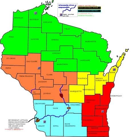
Marvaddin wrote:Blocky! And still very bad designed continents.
I don't care that it is blocky, counties are like that. But I do agree that the continients need work. I think NEW (North Eastern Wisconsin) (where Green Bay is) - that continent could be a just a little larger to cut down from the size of the north woods stuff. (Just a suggestion) And what happened to lake winabego? that sounded like a good idea.
Wisconsin is a great place!
-
DublinDoogey
- Posts: 329
- Joined: Tue Feb 28, 2006 7:03 pm
- Location: Wisconsin
Here's a possibe idea/solution to the general blockiness created by using modern day counties.
What if you used the (former) areas of different Indian tribes as the continents, and then used historic and/or modern sites, towns, parks, etc, named using Indian words or after Indians and/or tribes? (if that makes any sense)
Here's a picture to get you started:

Much of Wisconsin used to be forests, so, at least in the northern half, you can just use forests as natural barriers between continents/countries.
What if you used the (former) areas of different Indian tribes as the continents, and then used historic and/or modern sites, towns, parks, etc, named using Indian words or after Indians and/or tribes? (if that makes any sense)
Here's a picture to get you started:
Much of Wisconsin used to be forests, so, at least in the northern half, you can just use forests as natural barriers between continents/countries.
-
happysadfun
- Posts: 1251
- Joined: Mon Jul 10, 2006 9:06 pm
- Location: Haundin at DotSco, Being Sad that Mark Green Lost in Suburban Wisconsin
DublinDoogey wrote:Here's a possibe idea/solution to the general blockiness created by using modern day counties.
What if you used the (former) areas of different Indian tribes as the continents, and then used historic and/or modern sites, towns, parks, etc, named using Indian words or after Indians and/or tribes? (if that makes any sense)
Here's a picture to get you started:
Much of Wisconsin used to be forests, so, at least in the northern half, you can just use forests as natural barriers between continents/countries.
Well most of the southern ones are actually tv viewing areas. and the north is everything else. i've dropped the idea for now but i'm probably just going to work on the south africa map for now and come back to this one later.
Children, this is what happens to hockey players, druggies, and Hillary Clinton.Rope. Tree. Hillary. Some assembly required.
forget the river
sorry man, forget putting in the river. just forget putting in anything, almost every map of an american state looks extremely boring.
-
gavin_sidhu
- Posts: 1428
- Joined: Mon May 22, 2006 6:16 am
- Location: Brisbane, Australia
Re: forget the river
I think this map is abandoned.CheWolfe wrote:sorry man, forget putting in the river. just forget putting in anything, almost every map of an american state looks extremely boring.
Highest Score: 1843 Ranking (Australians): 3