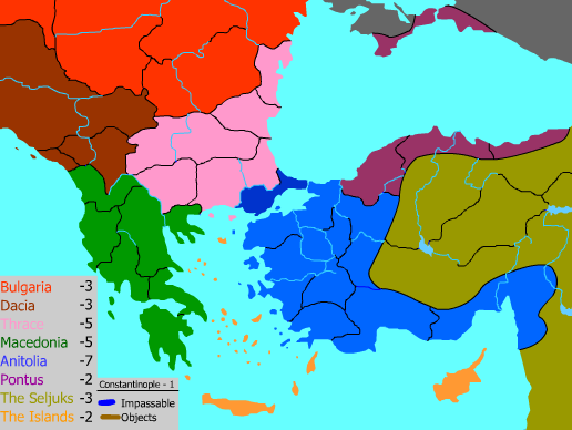
Number of Countries: 54
Number of Continents: 8
I based this map off of the historical condition of the Byzantine Empire at and around the years of the Third Crusade - roughly 1100 - 1200 AD
The borders of the empire are nearly accurate. For the most part, though, the individual provinces and many of the continents I had to take large creative leeway with.
The names come either from the region/province that was there, or one of the major cities in that area at that time.
This is a rough version, that gives a solid idea of the layout and general appearance. I wanted to wait to add the textures, final lines/colors, and finalize the nametag placement until I heard opinions on the borders and province layout.
This was a blast to make, and something I had always wanted to see
EDIT: I took out the province names and river/mountain terrain on the request for an uncluttered version. They'll be there, don't worry.
[Most of the visual aids I used were taken from reference texts and map books - not much I can post as a link, sorry]