High Seas [Quenched]

Care to peruse completed maps? Take a stroll through the Atlas.

Moderator: Cartographers

Forum rules
Please read the Community Guidelines before posting.
User avatar
oaktown
Posts: 4451
Joined: Sun Dec 03, 2006 9:24 pm
Location: majorcommand

Re: High Seas, circle work pg.12 [I, GP]

Post by oaktown »

edbeard wrote:As long as centering is possible then I think it doesn't matter too much.

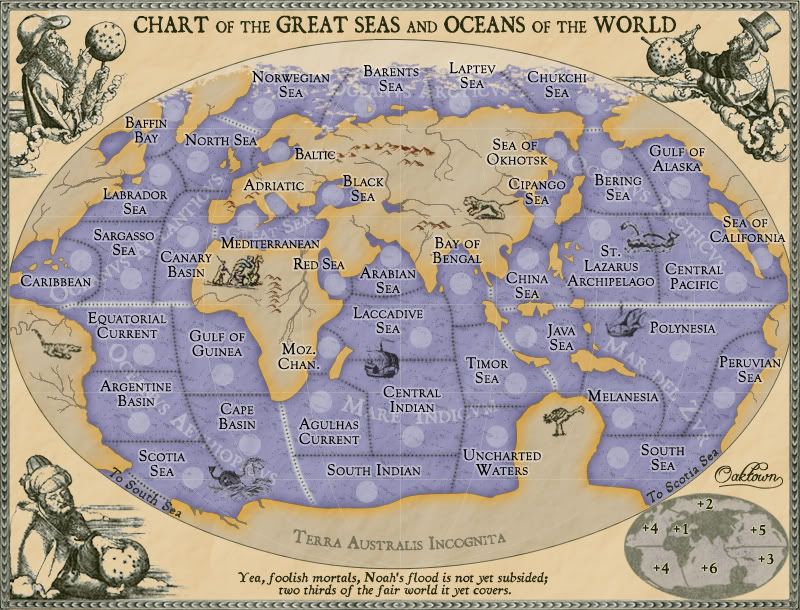
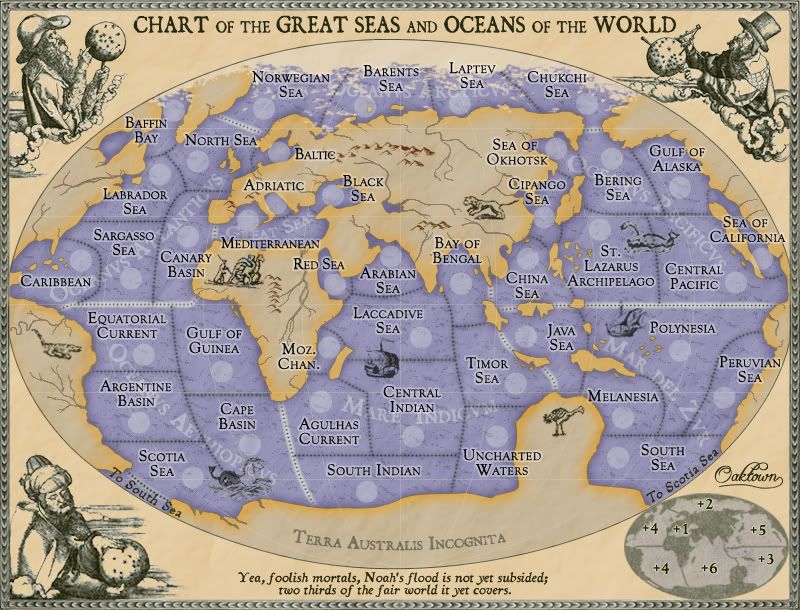
right - centering shouldn't be a problem (knock on wood).

edbeard wrote:Those seem fine but I didn't look too closely.

If you had, you would've noticed that I somehow missed the Baltic circle.

edbeard wrote:Why don't you see how it looks without them? It doesn't seem like a map where circles are necessary.

The sea color is just dark enough that I have trouble with the numbers sans-circles. Other problems are the waves, the ice floes in the arctic, and the narrow regions like Adriatic where the army counts will cross from water to land.

I'm going to bump the adriatic circle and title up a bit to get the circle off the border, but other than that I'm just sittin' around waiting for suggestions.

edit: done and done.
Image
[bigimg]http://i141.photobucket.com/albums/r76/ron_parodi/highseas24.jpg[/bigimg]
User avatar
gimil
Posts: 8599
Joined: Sat Mar 03, 2007 12:42 pm
Gender: Male
Location: United Kingdom (Scotland)

Re: High Seas, circle work pg.12 [I, GP]

Post by gimil »

How is this for your troubles?

Image
What do you know about map making, bitch?
natty_dread wrote:I was wrong
Top Score:2403
User avatar
yeti_c
Posts: 9624
Joined: Thu Jan 04, 2007 9:02 am
Gender: Male

Re: High Seas, circle work pg.12 [I, GP, Gr]

Post by yeti_c »

Why use circles if you don't like them? What about another shape... something more in keeping with the theme?

C.
Image
Highest score : 2297
User avatar
MrBenn
Posts: 6880
Joined: Wed Nov 21, 2007 9:32 am
Location: Off Duty

Re: High Seas, circle work pg.12 [I, GP, Gr]

Post by MrBenn »

Could you use a small boat-shaped shadow? It might look a bit rubbish though :?
bryguy
Posts: 4381
Joined: Tue Aug 07, 2007 8:50 am
Location: Lost in a Jigsaw

Re: High Seas, circle work pg.12 [I, GP, Gr]

Post by bryguy »

i myself love this map, easy gameplay (no way u could get confused on this one), great graphix, and i love the old parchment look


few things tho

1) You have to take a second glance to see that there is a 'to so south sea' and 'to scotia sea'
2) I like the dotted lines, and i noticed that u put them over the ships to if u needed to, yet u didnt for the thing between scotia sea and cape basin, could u?
3) this is probably unimportant, but u cant really read the white text saying what the seas are (the white text under the territory names)

other than those 3 things, i think this map is good to go
User avatar
iancanton
Foundry Foreman
Foundry Foreman
Posts: 2453
Joined: Fri Jun 01, 2007 5:40 am
Location: europe

Re: High Seas, update pg.11 [I, GP]

Post by iancanton »

oaktown wrote:I acknowledge that africa is still too low, but I've taken the liberty of showing it incorrectly because otherwise the northern hemisphere territories are going to be an absolutely mess. As for ancient mariners getting the geography correct, you're absolutely right. But the mapmakers of the day generally weren't so knowledgeable, and they often took liberties or just plain made things up, as I have.


without changing any territory borders, there is one thing that we can do to make the equator intersect africa in the right place: use the river that's currently in west africa as the new african coastline by colouring in everything to the south as blue sea (in other words, expanding gulf of guinea territory). the shape of africa will be distorted (as it often was on those maps, since longitude was difficult to measure) while keeping the integrity of the equator's known location relative to the african coastline.

ian. :)
User avatar
oaktown
Posts: 4451
Joined: Sun Dec 03, 2006 9:24 pm
Location: majorcommand

Re: High Seas, update pg.11 [I, GP]

Post by oaktown »

iancanton wrote:without changing any territory borders, there is one thing that we can do to make the equator intersect africa in the right place: use the river that's currently in west africa as the new african coastline by colouring in everything to the south as blue sea (in other words, expanding gulf of guinea territory). the shape of africa will be distorted (as it often was on those maps, since longitude was difficult to measure) while keeping the integrity of the equator's known location relative to the african coastline.

ian. :)

That works for me... I'll make it happen if/when I have some free time.
User avatar
oaktown
Posts: 4451
Joined: Sun Dec 03, 2006 9:24 pm
Location: majorcommand

Re: High Seas, circle work pg.12 [I, GP, Gr]

Post by oaktown »

[bigimg]http://i141.photobucket.com/albums/r76/ron_parodi/highseas25.jpg[/bigimg]
updated as per iancanton's excellent suggestion... africa slightly redrawn to set the equator right, and I dropped some islands in at appropriate places.
User avatar
TaCktiX
Posts: 2392
Joined: Mon Dec 17, 2007 8:24 pm
Gender: Male
Location: Rapid City, SD

Re: High Seas, latest pg. 1 & 13 [I, GP, Gr]

Post by TaCktiX »

I really like the new distortion to Africa, it adds to the aged and inaccurate feel of the geography on the map. Nice work on this Oaktown, and good suggestion iancanton.
User avatar
Unit_2
Posts: 1834
Joined: Sun Jan 14, 2007 12:59 pm
Gender: Male
Location: Pennsylvania, U.S.A, North America, Earth, Milky Way, Universe.

Re: High Seas, latest pg. 1 & 13 [I, GP, Gr]

Post by Unit_2 »

I like what you have done but look at the divider line, it kinda faints in a few places, is it suppost to be that way?
Image
User avatar
oaktown
Posts: 4451
Joined: Sun Dec 03, 2006 9:24 pm
Location: majorcommand

Re: High Seas, latest pg. 1 & 13 [I, GP, Gr]

Post by oaktown »

Unit_2 wrote:I like what you have done but look at the divider line, it kinda faints in a few places, is it suppost to be that way?

if you mean the equator, yes it is supposed to be faint. It doesn't really play any part in the game, so making it any more prominent would only be confusing.
User avatar
Ruben Cassar
Posts: 2160
Joined: Thu Nov 16, 2006 6:04 am
Gender: Male
Location: Civitas Invicta, Melita, Evropa

Re: High Seas, latest pg. 1 & 13 [I, GP, Gr]

Post by Ruben Cassar »

I noticed that all your sea/ocean regions' names are in Latin apart from the Mediterranean area which you called Great Seas.

Why not call it Mare Mediterraneus or Mare Nostrum as the Romans used to call it to stick with Latin?
ImageImageImageImageImage
User avatar
oaktown
Posts: 4451
Joined: Sun Dec 03, 2006 9:24 pm
Location: majorcommand

Re: High Seas, latest pg. 1 & 13 [I, GP, Gr]

Post by oaktown »

Ruben Cassar wrote:I noticed that all your sea/ocean regions' names are in Latin apart from the Mediterranean area which you called Great Seas.

Why not call it Mare Mediterraneus or Mare Nostrum as the Romans used to call it to stick with Latin?

I wanted the region name to encompass the adriatic and black sea as well, and to be something that would make it obvious that it does so. Also, calling it mediterraneus has the potential to be confused with the region "Mediterranean" - though the Nostrum idea might work. I still like keeping it simple, so if anybody else has any thoughts on that...
Image
bryguy
Posts: 4381
Joined: Tue Aug 07, 2007 8:50 am
Location: Lost in a Jigsaw

Re: High Seas, circle work pg.12 [I, GP, Gr]

Post by bryguy »

bryguy wrote:i myself love this map, easy gameplay (no way u could get confused on this one), great graphix, and i love the old parchment look


few things tho

1) You have to take a second glance to see that there is a 'to so south sea' and 'to scotia sea'
2) I like the dotted lines, and i noticed that u put them over the ships to if u needed to, yet u didnt for the thing between scotia sea and cape basin, could u?
3) this is probably unimportant, but u cant really read the white text saying what the seas are (the white text under the territory names)

other than those 3 things, i think this map is good to go


just wondering if u saw this


btw cant wait to play!
User avatar
TaCktiX
Posts: 2392
Joined: Mon Dec 17, 2007 8:24 pm
Gender: Male
Location: Rapid City, SD

Re: High Seas, latest pg. 1 & 13 [I, GP, Gr]

Post by TaCktiX »

I'm with Ruben in voting for naming consistency. It's jarring theme-wise to be going through all these beautiful old-style Latin names for regions, then suddenly there's "Great Sea", which smacks so much of modern-day thinking. Mare Nostrum should work, as you've already noted.
User avatar
yeti_c
Posts: 9624
Joined: Thu Jan 04, 2007 9:02 am
Gender: Male

Re: High Seas, latest pg. 1 & 13 [I, GP, Gr]

Post by yeti_c »

"Mare Internum" could work... taken from... (Internal Sea)

http://en.wikipedia.org/wiki/Mediteranean_sea

C.
Image
Highest score : 2297
User avatar
Ruben Cassar
Posts: 2160
Joined: Thu Nov 16, 2006 6:04 am
Gender: Male
Location: Civitas Invicta, Melita, Evropa

Re: High Seas, latest pg. 1 & 13 [I, GP, Gr]

Post by Ruben Cassar »

Yes the Romans used to call it Mare Nostrum or Mare Internum. The former was more common.

As far as I know the Adriatic sea is considered as part of the Mediterreanean sea just like the Tyrrhennian, Ionian and Aegean seas.
ImageImageImageImageImage
User avatar
oaktown
Posts: 4451
Joined: Sun Dec 03, 2006 9:24 pm
Location: majorcommand

Re: High Seas, latest pg. 1 & 13 [I, GP, Gr]

Post by oaktown »

Ruben Cassar wrote:Yes the Romans used to call it Mare Nostrum or Mare Internum. The former was more common.

While Mare Nostrum would fit the space better, I like Mare Internum - it could be argued that the Black Sea fits this identification as well. Oh wait... here it is! Made some other little clarity changes as well, such as making the the bonuses a bit larger on the inset map.
[bigimg]http://i141.photobucket.com/albums/r76/ron_parodi/highseas26.jpg[/bigimg]

Ruben Cassar wrote:As far as I know the Adriatic sea is considered as part of the Mediterreanean sea just like the Tyrrhennian, Ionian and Aegean seas.

Sure, but I can't very well have a two territory region with one border - it is an easy enough bonus as it is. The Adriatic was added after the link to the Red Sea was dropped.
User avatar
Ruben Cassar
Posts: 2160
Joined: Thu Nov 16, 2006 6:04 am
Gender: Male
Location: Civitas Invicta, Melita, Evropa

Re: High Seas, latest pg. 1 & 13 [I, GP, Gr]

Post by Ruben Cassar »

oaktown wrote:
Ruben Cassar wrote:As far as I know the Adriatic sea is considered as part of the Mediterranean sea just like the Tyrrhennian, Ionian and Aegean seas.

Sure, but I can't very well have a two territory region with one border - it is an easy enough bonus as it is. The Adriatic was added after the link to the Red Sea was dropped.


Yes, I totally agree with that. I thought you meant something else when I replied that post.
ImageImageImageImageImage
User avatar
ZeakCytho
Posts: 1251
Joined: Wed Sep 12, 2007 4:36 pm

Re: High Seas, latest pg. 1 & 13 [I, GP, Gr]

Post by ZeakCytho »

Some of the rivers look pixely/jagged compared to other things on land (animals, mountains, etc.). I suggested a while ago that you reduce the opacity on the layers for land-stuff (animals, mountains, rivers, etc.) - not sure if you missed that or just disagree.

There's some weirdness in the minimap by South America/Antarctica - they look like they're connecting, almost. I think this is because on the Scotia sea, you have a dotted line between the territory and the "To South Sea." But on the South Sea territory, this line isn't there. Personally, I don't think the line is necessary. It's obvious enough that they're two separate continents.

Other than those things, this map is looking great!
User avatar
AndyDufresne
Posts: 24935
Joined: Fri Mar 03, 2006 8:22 pm
Location: A Banana Palm in Zihuatanejo
Contact:

Re: High Seas, latest pg. 1 & 13 [I, GP, Gr]

Post by AndyDufresne »

I like the name change from Great Seas. The latest maps in the Foundry are looking top notch...and this one is certainly a beauty (and has game play I'd understand, ;)).


--Andy
User avatar
yeti_c
Posts: 9624
Joined: Thu Jan 04, 2007 9:02 am
Gender: Male

Re: High Seas, latest pg. 1 & 13 [I, GP, Gr]

Post by yeti_c »

ZeakCytho wrote:There's some weirdness in the minimap by South America/Antarctica - they look like they're connecting, almost. I think this is because on the Scotia sea, you have a dotted line between the territory and the "To South Sea." But on the South Sea territory, this line isn't there. Personally, I don't think the line is necessary. It's obvious enough that they're two separate continents.


That territory just wraps round on to the other side of the map... hence the singular territory border on the 1 side.

Having said that though - that border looks different to all the others!!

C.
Image
Highest score : 2297
User avatar
oaktown
Posts: 4451
Joined: Sun Dec 03, 2006 9:24 pm
Location: majorcommand

Re: High Seas, latest pg. 1 & 13 [I, GP, Gr]

Post by oaktown »

yeti_c wrote:Having said that though - that border looks different to all the others!!

huh, you're right... somehow I didn't catch it in the last change to the borders, which suggests its got its own layer - probably has all along. Weird.
Image
User avatar
Ruben Cassar
Posts: 2160
Joined: Thu Nov 16, 2006 6:04 am
Gender: Male
Location: Civitas Invicta, Melita, Evropa

Re: High Seas, latest pg. 1 & 13 [I, GP, Gr]

Post by Ruben Cassar »

Change the text to Mare Internvm to be in line with the other oceans and seas. Wonderful Latin. ;)
ImageImageImageImageImage
User avatar
yeti_c
Posts: 9624
Joined: Thu Jan 04, 2007 9:02 am
Gender: Male

Re: High Seas, latest pg. 1 & 13 [I, GP, Gr]

Post by yeti_c »

Ruben Cassar wrote:Change the text to Mare Internvm to be in line with the other oceans and seas. Wonderful Latin. ;)


He's got a point.

C.
Image
Highest score : 2297
Post Reply

Return to “The Atlas”