
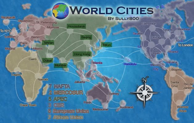
I'm not liking the idea of using treaties and unions and stuff. Some of the nations in Europe aren't even in the Union, APEC includes CER and NAFTA, it's all over the place basicly.
APEC = Asian Pacific Economic Cooperation
Why India and Dubai are in this... I'd say go back to the classics...Europe, Asia, Africa, Oceania, North America, South America.
The map formerly known as World Cities
Moderator: Cartographers
Forum rules
Please read the Community Guidelines before posting.
Please read the Community Guidelines before posting.
Re: World Cities (V6, 5/03/09)
Last edited by Merker on Mon May 04, 2009 4:17 am, edited 1 time in total.
-----Spanish Civil War: VacationedMrBenn wrote: On an a side-note, as a child I used to have a recurring nightmare about being chased round a supermarket by a crocodile pushing a shopping trolley and wearing an "I ♥ Shopping" t-shirt...

Re: World Cities (V6, 5/03/09)
You're right - the globe centred on Oz looks bad due to the vastness of the ocean... You should have just told me where to go 

PB: 2661 | He's blue... If he were green he would die | No mod would be stupid enough to do that
-
sully800

- Posts: 4978
- Joined: Wed Jun 14, 2006 5:45 pm
- Gender: Male
- Location: Bethlehem, Pennsylvania
Re: World Cities (V6, 5/03/09)
Finished my last undergraduate final this morning, hence all the time for rapid updates.
Lack has mentioned that I have half a good idea for making this map work properly (I believe that is the cities as the building block, as well as the split along the Atlantic ocean). I think the half that is not working properly is my current bonus region layout, so it will possibly need more work and creative thinking. As for the earlier continent about just including a mini-map: That works for labeling the bonuses clearly, but bonus regions need names because they are included in the XML and show up in the game log. If I'm not allowed to use continent names (I'm not sure if that will officially be the case) then I'm still not sure what to do.
Oh, I also changed the army shadows to be a solid color instead of the textured white I created in my first draft. No one ever complained about it, but I was never particularly happy with those shadows so let me know what you think of their plainer cousins.
FixedIf you have "European Union" shouldn't it be "African Union" as well?
While they are close geographically, I don't wish to connect them for the gameplay reasons mentioned on the previous pages. I think the continents are properly balanced right now as South America in classic has only two borders and is similar to my African Union. I nudged the army circles apart a bit to make it clear that they do not connect.I think Cairo to Dubai should be in there.
Fixed both of those lines, as well as several others that were unnecessarily hitting city labels such as Las Vegas. I also straightened the line from NY to London because it was looking far too squiggly.sully, a small small thing to start with, the line between cairo and athens is pretty obscured, it'd be great for it to be a bit more visible. NYC-Montreal could also be a bit more pronounced.
I'm inclined to agree with you about the trade organizations and unions, because the cities I've included don't fit neatly into groups, and there is overlap between many of the organizations.I'm not liking the idea of using treaties and unions and stuff. Some of the nations in Europe aren't even in the Union, APEC includes CER and NAFTA, it's all over the place basicly.
Lack has mentioned that I have half a good idea for making this map work properly (I believe that is the cities as the building block, as well as the split along the Atlantic ocean). I think the half that is not working properly is my current bonus region layout, so it will possibly need more work and creative thinking. As for the earlier continent about just including a mini-map: That works for labeling the bonuses clearly, but bonus regions need names because they are included in the XML and show up in the game log. If I'm not allowed to use continent names (I'm not sure if that will officially be the case) then I'm still not sure what to do.
Come to Bethlehem and hang out in the miserable rain with me and JRMrBenn wrote:You're right - the globe centred on Oz looks bad due to the vastness of the ocean... You should have just told me where to go
Oh, I also changed the army shadows to be a solid color instead of the textured white I created in my first draft. No one ever complained about it, but I was never particularly happy with those shadows so let me know what you think of their plainer cousins.
- Click image to enlarge.

-
thenobodies80

- Posts: 5400
- Joined: Wed Sep 05, 2007 4:30 am
- Gender: Male
- Location: Milan
Re: World Cities (V7, 5/04/09)
Hi Sully,
Not much to say:
Currently the North America seems different from other continents. It is floating much more than any other continents on water.Probably the dark shadow ? .
.
Personally, i don't like that some names cover/touch the army circles, can you move them only a bit?
And I don't like dark border between APEC/EU (near moscow/St.Petersburg names), it's more darker compared with others.
The route Mexico city-Havana is a bit difficult to see, try to draw it on the sea rather than on land
Finally, i suppose you could have some problems with 888 with NYC, probably the name will be covered.
You're doing a great map!
TNBDS
Not much to say:
Currently the North America seems different from other continents. It is floating much more than any other continents on water.Probably the dark shadow ?
Personally, i don't like that some names cover/touch the army circles, can you move them only a bit?
And I don't like dark border between APEC/EU (near moscow/St.Petersburg names), it's more darker compared with others.
The route Mexico city-Havana is a bit difficult to see, try to draw it on the sea rather than on land
Finally, i suppose you could have some problems with 888 with NYC, probably the name will be covered.
You're doing a great map!
TNBDS
-
AndyDufresne

- Posts: 24935
- Joined: Fri Mar 03, 2006 8:22 pm
- Location: A Banana Palm in Zihuatanejo
- Contact:
Re: World Cities (V7, 5/04/09)
Straying away from Continent names is indeed a way that we'll have to continue to go. Lack has also suggested making the continents, as they are represented on the map, physically less...prominent. Put the prominence on the city locales rather than on the geography behind them, is his thinking I believe.
--Andy
--Andy
Re: World Cities (V7, 5/04/09)
HmmAndyDufresne wrote:Straying away from Continent names is indeed a way that we'll have to continue to go. Lack has also suggested making the continents, as they are represented on the map, physically less...prominent. Put the prominence on the city locales rather than on the geography behind them, is his thinking I believe.
--Andy
One solution may be to make the background (land) more uniform in colour, and add a more solid background to the country names? This example looks rubbish, so it might be another thing about which where you can tell me where to go
PB: 2661 | He's blue... If he were green he would die | No mod would be stupid enough to do that
-
sully800
- Posts: 4978
- Joined: Wed Jun 14, 2006 5:45 pm
- Gender: Male
- Location: Bethlehem, Pennsylvania
Re: World Cities (V7, 5/04/09)
Hmmm, then I suppose the best way to go would be to make a satellite type image with real earth tones and highlight each city in its actual surroundings.AndyDufresne wrote:Straying away from Continent names is indeed a way that we'll have to continue to go. Lack has also suggested making the continents, as they are represented on the map, physically less...prominent. Put the prominence on the city locales rather than on the geography behind them, is his thinking I believe.
--Andy
Something more like this:

I can enlarge the current globe and put a second one on the other side of the title and use that as the "mini map" to show bonuses. We still have a problem with naming the bonus regions however, because I'm not sure the current trade alliances are accurate enough. And if we are not grouping the cities by continent anyway we don't need to be so restricted with the names.
This will take a decent amount of work but I will continue to think of different ways to approach it!
-
Merciless Wong
- Posts: 199
- Joined: Wed Feb 06, 2008 8:12 pm
Re: World Cities (V7, 5/04/09)
Perhaps instead of having the continents... have an abstract map with the lines and circles floating above an image (or a mix of image from different cities ... modern, less modern) .
Y'know like the early version of prince of the city...that got shot down. The one with lines and circles floating above a picture of a city.
Y'know like the early version of prince of the city...that got shot down. The one with lines and circles floating above a picture of a city.
-
LED ZEPPELINER
- Posts: 1088
- Joined: Tue Nov 25, 2008 10:09 pm
Re: World Cities (V7, 5/04/09)
I think that it is currently too dark
sailorseal wrote:My big boy banana was out the whole time
AndyDufresne wrote:Forever linked at the hip's-banana! (That sounds strange, don't quote me.)AndyDufresne wrote:Many Happy Bananas to everyone, lets party...with Bananas.
--Andy

Re: World Cities (V5, 4/30/09)
Yeh exactly. Good to see it's in now!gho wrote:I agree. 1/3 of NZ's populations lives in Auckland (pop. 1.3mil), while only 380k live in Wellington (its the third largest city). From a airline point of view (that this map shows), aukland gets the majority of flights.thedon5 wrote:
I like it.
Only thing, is that in NZ, the main city is Auckland
With the continents, if you cant use the real continents, why dont you just use a mini map without continent names on the xml just being colours?
I reckon it would look good with the brighter colours than the darker ones, makes it more pleasant, and easier to read!
-
sully800
- Posts: 4978
- Joined: Wed Jun 14, 2006 5:45 pm
- Gender: Male
- Location: Bethlehem, Pennsylvania
Re: World Cities (V7, 5/04/09)
This version is not extremely refined because of all the big updates, so excuse any attack lines that are not clear or pretty at the moment. Most noticeably I dished all the bonus region colors and created a natural view of the earth. This was really experimental as I had no guide to go off of, but I am pretty pleased with the final result! I know it's not very clear where the cities belong now, especially if you are colorblind so that will have to be fixed later. The other big changes deal with gameplay and attack routes. I have reverted the gameplay so it is very similar to the first version and my original goal. I think all regions are working well now except for the cities in Europe. Getting those attack routes to match up properly was quite difficult and took a lot of adjusting. You will notice that Moscow is now on the Asian continent and Tehran from Asia has been switched to Volgograd (European). This was all done to accommodate the current gameplay which should be finalized. If you have a better way of organizing europe while keeping the exact same attack routes please let me know (please think of that part as a revamp - you can interchange cities, and move all the lines but the gameplay will stay the same as shown right now I hope).
- Click image to enlarge.

Re: World Cities (V8, 5/06/09)
I like the new look. With the mini map, you should make the bonus numbers the colour of the continents. I also think you should expand Europe out east, get rid of rome (which looks really bad where it currently is, add moscow to Europe and add another Asian city (theres thousands to choose from, I think for the map Kathmandu or Lhasa will nicely fill the space you have). I had never heard of novosibirsk before reading this map, maybe you should change it to Almaty or Astana of Kazakhstan (russia already has 3 cities). Also you might consider changing seattle to vancouver.
Re: World Cities (V8, 5/06/09)
That's looking really sharp  .
.
Asian city, eh? Hyderabad? Delhi? Chennai? Chandigarh?
How about Lima instead of Santa Cruz?
And never really heard of Volgograd or Lagos. Maybe Prague or Zagreb instead of Volgograd, and Lagos, well, it's not even the capital of Nigeria. How about Casablanca, Tripoli, Windhoek, Harare, Anatananarivo, Addis Ababa or Marrakesh instead?

Re: World Cities (V8, 5/06/09)
Rome looks a bit like it is in Africa - and not in Italy/Europe.
C.
C.

Highest score : 2297
Re: World Cities (V8, 5/06/09)
Yeh, seems a little cramped in Europe.yeti_c wrote:Rome looks a bit like it is in Africa - and not in Italy/Europe.
C.
Re: World Cities (V8, 5/06/09)
and if your going to keep paris in that location you might as well rename it berlin. Geographically more accurate and also one of the great European cities.
-
sully800
- Posts: 4978
- Joined: Wed Jun 14, 2006 5:45 pm
- Gender: Male
- Location: Bethlehem, Pennsylvania
Re: World Cities (V8, 5/06/09)
I started with Astana but chose novosibirsk because it is further north which was needed. You may not have heard of it, but it is Russia's third largest city (and Moscow/St. Petersburg are already included).gho wrote:I had never heard of novosibirsk before reading this map, maybe you should change it to Almaty or Astana of Kazakhstan (russia already has 3 cities). Also you might consider changing seattle to vancouver.
Santa Cruz is home to 1,528,683 and Lima is home to 7,605,742 so that seems like a good change.thedon5 wrote: How about Lima instead of Santa Cruz?
And never really heard of Volgograd or Lagos. Maybe Prague or Zagreb instead of Volgograd, and Lagos, well, it's not even the capital of Nigeria. How about Casablanca, Tripoli, Windhoek, Harare, Anatananarivo, Addis Ababa or Marrakesh instead?
Volgograd was formerly called Stalingrad which I'm sure you heard of, and was also known as Tsaritsyn
Lagos is the former capital of Nigeria and the largest Nigerian city (much like Sao Paulo vs Brasilia in Brazil). It is the second largest city in Africa to Cairo so I think it should stay.
I included Berlin and not Rome until this edition which worked out much better as far as the spacing. I placed Rome too far south and Paris too far north in the latest version so that Athens and Madrid could connect. I will freely admit that it is not a great solution and can probably be improved. If you have suggestions of how to rearrange Europe while keeping the exact same gameplay please let me know. I would like to switch the wrap around border back to London instead of Reykjavik as well but I couldn't find a way with this proposed connection map.gho wrote:and if your going to keep paris in that location you might as well rename it berlin. Geographically more accurate and also one of the great European cities.
-
SultanOfSurreal

- Posts: 97
- Joined: Thu Jul 03, 2008 3:53 am
- Gender: Male
Re: World Cities (V8, 5/06/09)
May I once again suggest Lhasa to make central asia less barren? With the circle and the name written above it, the map wouldn't have such an annoying bald spot. Lhasa is also an extremely important settlement these days, small population or no.
Also mark me down as a fan of the old look. The solid colors made the map look much simpler and cleaner. I hate maps that go overboard with graphics. Pearl Harbor is a wonderful map but a headache to look at; Iwo Jima on the other hand, is a nice, simple, classic-style map that I could spend hours playing on.
Also mark me down as a fan of the old look. The solid colors made the map look much simpler and cleaner. I hate maps that go overboard with graphics. Pearl Harbor is a wonderful map but a headache to look at; Iwo Jima on the other hand, is a nice, simple, classic-style map that I could spend hours playing on.
-
reggie_mac

- Posts: 299
- Joined: Fri Nov 30, 2007 4:06 pm
- Location: Queenstown, NZ
- Contact:
Re: World Cities (V8, 5/06/09)
I'd have to agree here, sometimes, less is more.SultanOfSurreal wrote:Also mark me down as a fan of the old look. The solid colors made the map look much simpler and cleaner. I hate maps that go overboard with graphics. Pearl Harbor is a wonderful map but a headache to look at; Iwo Jima on the other hand, is a nice, simple, classic-style map that I could spend hours playing on.
Soviet Invaders: Space Invaders, it's not just a game
New Zealand Map - Foundry
"You can please all of the people some of the time, or some of the people all of the time, but not all of the people all of the time"
New Zealand Map - Foundry
"You can please all of the people some of the time, or some of the people all of the time, but not all of the people all of the time"
-
sully800
- Posts: 4978
- Joined: Wed Jun 14, 2006 5:45 pm
- Gender: Male
- Location: Bethlehem, Pennsylvania
Re: World Cities (V8, 5/06/09)
Distinctly colored continents aren't going to be an option for this map, because the purpose is to highlight the cities and not the continents that they come from. I will continue to adjust the graphics as best I can which may involve toning down the green and brown shades if it will improve the overall look.
Lhasa is certainly a good choice for central Asia, because the area is indeed too empty. And as for the Europe problem, I'm thinking I will have to go intercontinental. The best way will probably be switching Cairo to the current EU group, and call it Europe + Mediterranean. Then I will add another African city and call that region Sub-saharan Africa. This will also help the problem of having bonus regions based on continents instead of on other geographic groupings. I'll play around with it while continuing to try and spread out the current European cities.
Lhasa is certainly a good choice for central Asia, because the area is indeed too empty. And as for the Europe problem, I'm thinking I will have to go intercontinental. The best way will probably be switching Cairo to the current EU group, and call it Europe + Mediterranean. Then I will add another African city and call that region Sub-saharan Africa. This will also help the problem of having bonus regions based on continents instead of on other geographic groupings. I'll play around with it while continuing to try and spread out the current European cities.


Re: World Cities (V8, 5/06/09)
might i suggest kathmandu? at least a reasonable number of planes actually flies to kathmandu while, to the best of my knowledge, no non-chinese airlines at all fly to lhasa - and i think a dead-end isn't what u have in mind.sully800 wrote:Lhasa is certainly a good choice for central Asia, because the area is indeed too empty.
ian.

Re: World Cities (V8, 5/06/09)
Post a picture of the map without any of the territories and i will attempt to fix europe.sully800 wrote: If you have suggestions of how to rearrange Europe while keeping the exact same gameplay please let me know. I would like to switch the wrap around border back to London instead of Reykjavik as well but I couldn't find a way with this proposed connection map.
-
Incandenza

- Posts: 4949
- Joined: Thu Oct 19, 2006 5:34 pm
- Gender: Male
- Location: Playing Eschaton with a bucket of old tennis balls
Re: World Cities (V8, 5/06/09)
What if you moved Paris a bit to the east and renamed it Warsaw, then moved Madrid a bit to the northeast and called it Paris?
THOTA: dingdingdingdingdingdingBOOM
Te Occidere Possunt Sed Te Edere Non Possunt Nefas Est
Te Occidere Possunt Sed Te Edere Non Possunt Nefas Est
Re: World Cities (V8, 5/06/09)
You could colour the numbers in the minimaps the same colour as the city names?
C.
C.
Highest score : 2297
