- Click image to enlarge.

Magyarország [Quenched]
Moderator: Cartographers
Forum rules
Please read the Community Guidelines before posting.
Please read the Community Guidelines before posting.
-
koontz1973

- Posts: 6960
- Joined: Thu Jan 01, 2009 10:57 am


Re: Magyarország [26/6]
in left legend you have Czechoslovak republic and also in right one. but in middle legend there is Czechoslovakia. you should use the same name everywhere, I think somebody would be confused. no everybody knows that Czechoslovak republic and Czechoslovakia is the same.
why Tisza has not connection with Danube?
Oneyed
why Tisza has not connection with Danube?
Oneyed
-
koontz1973
- Posts: 6960
- Joined: Thu Jan 01, 2009 10:57 am
Re: Magyarország [26/6]
I am sure players are not that stupid but fixed it in the large. No room to do it in the small.Oneyed wrote:in left legend you have Czechoslovak republic and also in right one. but in middle legend there is Czechoslovakia. you should use the same name everywhere, I think somebody would be confused. no everybody knows that Czechoslovak republic and Czechoslovakia is the same.
no need for it to connect for any reason. It would not add anything to the map at all.why Tisza has not connection with Danube?
Oneyed
- Click image to enlarge.


Re: Magyarország [26/6]
I am not so sure. many people do not know that Czechoslovakia exist or where it lies. believe mekoontz1973 wrote: I am sure players are not that stupid but fixed it in the large. No room to do it in the small.
just for aesthetic look...koontz1973 wrote: It would not add anything to the map at all.
Oneyed
-
koontz1973
- Posts: 6960
- Joined: Thu Jan 01, 2009 10:57 am
Re: Magyarország [31/7]
I am sure many people do not know where it is, but I doubt many are stupid enough to confuse the two. As for using the modern name for it, that would then mean that all names would need updating. I have it the once for spacing reasons on the small map only now. As for the Tisza, refer to my previous answer.
Re: Magyarország [31/7]
Your mountains, you have a couple that seem to blend into the map more than some for instance:
 This one looks pretty good, a little tweaking and it'll be really good. But this one
 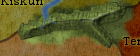 Notice the hard lines where the mountains meet the playable area? Get it looking more like the first example and I'll take another look
This one looks pretty good, a little tweaking and it'll be really good. But this one Notice the hard lines where the mountains meet the playable area? Get it looking more like the first example and I'll take another look -
koontz1973
- Posts: 6960
- Joined: Thu Jan 01, 2009 10:57 am
Re: Magyarország [1/8]
Your almighty wisdom has shown me the errors of my ways. Please accept these new images as way of apology. Please do not strike me down and show me how to gather the fruit to please you, oh mighty one.

- Click image to enlarge.

Re: Magyarország [1/8] Pg 1/11
See how the right side of this one is? 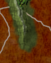 ? Do all of them like this and IMHO they'll be just about perfect!

? Do all of them like this and IMHO they'll be just about perfect! -
koontz1973
- Posts: 6960
- Joined: Thu Jan 01, 2009 10:57 am
Re: Magyarország [1/8] Pg 1/11
Hope this is what you meant.
- Click image to enlarge.

- Click image to enlarge.

Re: Magyarország [1/8] Pg 1/11
The one down by Csanada, could use a little more, maybe add some trees around the left side of it.
-
koontz1973
- Posts: 6960
- Joined: Thu Jan 01, 2009 10:57 am
Re: Magyarország [1/8] Pg 1/11
Extra glow and some trees thrown in so the locals can have some fire wood for cooking. Would not want them to starve.
- Click image to enlarge.

- Click image to enlarge.


Re: Magyarország [2/8] Pg 1/11
not sure what graphic software you use, but the image looks flat. I suggest adding an overlay with white/black highlights. Have the white (radial gradient) over the land so when the layer is set to overlay, it "pops" more.

-
koontz1973
- Posts: 6960
- Joined: Thu Jan 01, 2009 10:57 am
Re: Magyarország [2/8] Pg 1/11
RjBeals, thanks for the post. Firstly, GIMP is the software, and before you roll your eyes at it, I know PS is better but I am more comfortable with this one.
I understand your point, and have tried it with this and many other maps. But I just have never liked the effect it gives. Saying that though, cannot think of one good reason not to try it again.
3 glow spots on overlay at 30% opacity gives this.
I understand your point, and have tried it with this and many other maps. But I just have never liked the effect it gives. Saying that though, cannot think of one good reason not to try it again.
3 glow spots on overlay at 30% opacity gives this.
- Click image to enlarge.

- Click image to enlarge.

Re: Magyarország [10/8] Pg 1/11
I wouldn't roll my eyes at gimp. I've seen many kick ass maps (and other art) created in gimp. Here is what the effect looks like with photoshop. Yours looks good - I also adjusted the levels and color saturation a bit.
- Click image to enlarge.

-
koontz1973
- Posts: 6960
- Joined: Thu Jan 01, 2009 10:57 am
Re: Magyarország [10/8] Pg 1/11
Adjusted the saturation as recommended. While not as bright as yours, it is different enough now to really see the difference between the two parts of the map. Not done for the non playing areas as wanted those to be matt.
- Click image to enlarge.

- Click image to enlarge.

Re: Magyarország [10/8] Pg 1/11
would this be hard change for you? I can not see any difference from gameplay view.
also you have around playable area written names of countries (Kingdom of Romania, Austria...), it is possible to add there also Czechoslovak republic?
Oneyed
- Click image to enlarge.

Oneyed
Last edited by Oneyed on Fri Aug 10, 2012 12:51 pm, edited 1 time in total.
-
AndyDufresne

- Posts: 24935
- Joined: Fri Mar 03, 2006 8:22 pm
- Location: A Banana Palm in Zihuatanejo
- Contact:
Re: Magyarország [10/8] Pg 1/11
What change did you make or are suggesting? Notes are always helpful when you post images.
--Andy
--Andy
-
koontz1973
- Posts: 6960
- Joined: Thu Jan 01, 2009 10:57 am
Re: Magyarország [10/8] Pg 1/11
Oneyed, as for the change in position of the two territs, this is an old issue you have raised from an early development of this map. I have repeatedly said no to this and given my reasons for it. Please refer to any of the previous answers given. As for adding the Czechoslovak republic, will add that and not sure why I left it of. I had a reason some versions ago but cannot remember why. Will add tonight.
Re: Magyarország [10/8] Pg 1/11
because historic and geographic accuracy. where koontz has Szepes is Árva. and Szepes is where I moved it.AndyDufresne wrote:What change did you make or are suggesting? Notes are always helpful when you post images.
--Andy
Oneyed
-
koontz1973
- Posts: 6960
- Joined: Thu Jan 01, 2009 10:57 am
Re: Magyarország [10/8] Pg 1/11
New images with CR and Poland as well added. But while doing it, I remembered why they where not on. It makes the map top heavy. If that makes sense to you lot. But will leave them on for now unless one of the CAs tells me to take them of.
- Click image to enlarge.

- Click image to enlarge.

Re: Magyarország [10/8] Pg 1/11
yes. and I still not understand why you can not accept history and geography of my country.koontz1973 wrote:Oneyed, as for the change in position of the two territs, this is an old issue you have raised from an early development of this map.
your reasons for it were valid for this change. I understand them, this version change gameplay.koontz1973 wrote: I have repeatedly said no to this and given my reasons for it.
- Click image to enlarge.

- Click image to enlarge.
-
koontz1973
- Posts: 6960
- Joined: Thu Jan 01, 2009 10:57 am
Re: Magyarország [10/8] Pg 1/12
Because the two territs are part of Poland and not your country. Now, it you can give me accurate names from that era that would fit better, then do so.
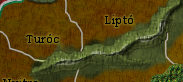
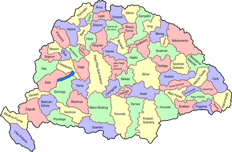
From the map that I have used which is accurate, Arva touches Turoc and Lipto. Szepes touches Lipto, Saros, Torna and Gomores.
With the map I have drawn Arva borders Turoc only. Not 100% accurate but the connection on the map exists.
Again, Szepes borders Lipto. Accurate but does not touch the other 3. It does not touch Saros or lipto as that would increase the borders to it. And Gomores is not even on the map.
So for accuracy, it is accurate for position to borders. As for removing Gomores, that was done for game play. As for removing borders, again that was done for game play.
Even with your map that you keep on insisting is accurate, is not. So it will not change and that is that.
Re: Magyarország [10/8] Pg 1/12
no. they were par of Slovak country long time before shows your map. for short time JUST PART of them were Polish, but then they were and still are part of Slovakia.koontz1973 wrote:Because the two territs are part of Poland and not your country. Now, it you can give me accurate names from that era that would fit better, then do so.
you are wrong here. you can not speak about all Árva and Szepes and their border. Polish Árva has no border with Turóc. Polish Szepes has not border with Liptó, Gomores and Sáros.koontz1973 wrote: From the map that I have used which is accurate, Arva touches Turoc and Lipto. Szepes touches Lipto, Saros, Torna and Gomores.
With the map I have drawn Arva borders Turoc only. Not 100% accurate but the connection on the map exists.
Again, Szepes borders Lipto. Accurate but does not touch the other 3. It does not touch Saros or lipto as that would increase the borders to it. And Gomores is not even on the map.
as I said JUST SMALL PARTS OF ÁRVA AND SZEPES WERE POLISH.
polish Árva
- Click image to enlarge.

- Click image to enlarge.

you can see that you are totaly off accuracy...koontz1973 wrote: So for accuracy, it is accurate for position to borders. As for removing Gomores, that was done for game play. As for removing borders, again that was done for game play.
...and yes, I have it accurate.koontz1973 wrote: Even with your map that you keep on insisting is accurate, is not. So it will not change and that is that.
all my advices are just to help you to do map better and accurate. when you can not take my help, then you need to do better research when you work on any map
Oneyed
-
koontz1973
- Posts: 6960
- Joined: Thu Jan 01, 2009 10:57 am
Re: Magyarország [10/8] Pg 1/12
And I can also produce a map after map that shows what I am saying is correct. We are not talking about Polish or Check territories. We are talking about territories that where in the kingdom of Hungary. And for this, I am correct.
- Click image to enlarge.
- Click image to enlarge.
