Russia map

Have an idea for a map? Discuss ideas and concepts here.

Moderator: Cartographers

Forum rules
Please read the Community Guidelines before posting.
cheese man
Posts: 21
Joined: Thu Mar 02, 2006 12:55 pm
Location: london

Russia map

Post by cheese man »

I'm making a map of Russia

Here's what i've done so far:
Image

Plese post your thoughts and coments and names for the left over countries.
ding dong dang
me is crazy

cheese man
User avatar
Haydena
Posts: 634
Joined: Sun Mar 19, 2006 2:43 pm
Location: Sussex, England

Post by Haydena »

I'm not an expert on map making but it looks like it needs much more countries, and one or two more continents, it looks like it has great potential though. I wouldn't give Far East Russia a bonus of 5 either, it only has one country to defend from.

As I say I'm no expert, I'm sure there are lots of other people who will happily give you much better advice :)
User avatar
thegrimsleeper
Posts: 984
Joined: Thu Jan 26, 2006 10:40 am
Location: Seattle
Contact:

Post by thegrimsleeper »

Well I hope this is just a rough draft, because you're going to need to do a whole new map at some point, those graphics are straight preschool.

There's exactly half as many countries as the classic map. I think we'd like to see a map with less than 42 countries one day, but Russia is just too huge to be that map. And you're going to need 2 more continents as well.
User avatar
johnnyrotten
Posts: 2883
Joined: Sat Mar 04, 2006 4:42 pm
Gender: Male
Location: Poole, England

Post by johnnyrotten »

thegrimsleeper wrote:Well I hope this is just a rough draft, because you're going to need to do a whole new map at some point, those graphics are straight preschool.


Not much worse than the Middle East map...
User avatar
thegrimsleeper
Posts: 984
Joined: Thu Jan 26, 2006 10:40 am
Location: Seattle
Contact:

Post by thegrimsleeper »

At least the Middle East map had a bit of a theme... This looks like it was done in Paint in 10 minutes...

...On second thought, make that 5.
User avatar
Haydena
Posts: 634
Joined: Sun Mar 19, 2006 2:43 pm
Location: Sussex, England

Post by Haydena »

The middle east map looked a bit better than that really. It does look like it was done in paint actually :lol:
cheese man
Posts: 21
Joined: Thu Mar 02, 2006 12:55 pm
Location: london

Post by cheese man »

I know it looks bad at the moment but i'm still doing the graphics

And its not done in paint, it's done in photoshop. it looks bad 'cos i don't know how to use it well.

Here's an update:
Image
ding dong dang
me is crazy

cheese man
User avatar
Marvaddin
Posts: 2545
Joined: Thu Feb 09, 2006 5:06 pm
Location: Belo Horizonte, Brazil

Post by Marvaddin »

Update? You changed only the background colour, dont you?

"There's exactly half as many countries as the classic map. I think we'd like to see a map with less than 42 countries one day, but Russia is just too huge to be that map. And you're going to need 2 more continents as well."
- Totally agreed. You will need much more countries and at least 2 more continents. So, I will not discuss bonuses now.

Three more little comments: 1st, dont use vertical names, please (North Land name even doesnt need to be vertical). 2nd, use some smaller fonts, at least for the legend. A huge legend isnt necessary. 3rd, use thinner borders, or it can be a problem when the map has more countries.
Image
User avatar
casper
Posts: 416
Joined: Wed Feb 01, 2006 6:36 pm
Location: Chicago
Contact:

Post by casper »

you need a lot more territories and also some graphic design skills might help...
User avatar
DublinDoogey
Posts: 329
Joined: Tue Feb 28, 2006 7:03 pm
Location: Wisconsin

Post by DublinDoogey »

You've got a really good start with the map so far. from what i've learned w/ my north america map, and playing the site i have a few pointers...

:arrow: take the time to learn photoshop, it's actually a lot fun. as you learn more about photoshop your graphics will improve just because you'll have cool tools to use
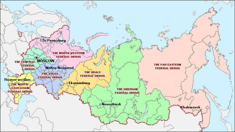
:arrow: russia's a huge country (the largest, land wise, i believe) so take advantage of that. there are plenty of areas and places you can make into countries. for example, i don't know where it is, but Chechnya(sp?) comes to mind immediatly, only because it's been in the news. if you don't feel you have room to add more countries, make it a USSR map, it would add lots more room

:arrow: leave the bonuses out for now, especially as new countries are added and adjusted.

:arrow: one more thing, and just because i see way too much of it... please don't use times new roman as the font for the map, just a personal thing, but i figured i'd throw that in

Good luck! Keep chuggin along with it. I hope to play on it sometime soon :D
cheese man
Posts: 21
Joined: Thu Mar 02, 2006 12:55 pm
Location: london

Post by cheese man »

here a have done everything u suggested:
Image
How it look
ding dong dang
me is crazy

cheese man
User avatar
Marvaddin
Posts: 2545
Joined: Thu Feb 09, 2006 5:06 pm
Location: Belo Horizonte, Brazil

Post by Marvaddin »

60 countries? I think we dont need that much... 42, 45 or 48 are good numbers... It will probably make easier divide the continents too. Post the map with the division, and, if its possible, make some non-linear borders :wink:
Image
cheese man
Posts: 21
Joined: Thu Mar 02, 2006 12:55 pm
Location: london

Post by cheese man »

okaaaaaaaaaaaaaaay

illsee someone elses apinion
ding dong dang
me is crazy

cheese man
User avatar
AndyDufresne
Posts: 24935
Joined: Fri Mar 03, 2006 8:22 pm
Location: A Banana Palm in Zihuatanejo
Contact:

Post by AndyDufresne »

Quite a few too many countries. And as Marv said try to go with more traditional borders non-linear borders. It makes it look like "countries" more and less like a road map of russia. Once you knock out the "continents" and get them bonused and balanced, it could be a very playable map.

It's much better than what you originally started on, but keep working and striving to achieve greatness.

--Andy
User avatar
thegrimsleeper
Posts: 984
Joined: Thu Jan 26, 2006 10:40 am
Location: Seattle
Contact:

Post by thegrimsleeper »

If you're going to make a map with more than 42 countries, Russia would be a great area to use.

HOWEVER.

If you're going to make a map at all, you've gotta bring some skills to the graphics. First drafts never look good, so we're not judging too harshly just yet. Having said that, the others are definitely right about the non-linear boundries: It's just much more aesthetically pleasing to have "natural" divisions between countries.

Remember that you've gotta have room for the country's name and number of troops, so if you can't fit it all in without cramming, it might be best to try and stick with a number closer to 42.
User avatar
AndyDufresne
Posts: 24935
Joined: Fri Mar 03, 2006 8:22 pm
Location: A Banana Palm in Zihuatanejo
Contact:

Post by AndyDufresne »

Remember that you've gotta have room for the country's name and number of troops, so if you can't fit it all in without cramming, it might be best to try and stick with a number closer to 42.


I'd agree with that. Also for name shortening for a few of the "directional countries" abbreviations could be used. N. Lands, W. Yakutia, S. Evenkia, etc. Though there aren't many, it'd still help. But limiting the countries to a smaller number would greatly improve adequate space for names and army numbers.

--Andy
cheese man
Posts: 21
Joined: Thu Mar 02, 2006 12:55 pm
Location: london

Post by cheese man »

here is it with some courvy lines:
Image
Should I start splitting it up now into contonents and start makeing the graphics better
ding dong dang
me is crazy

cheese man
User avatar
thegrimsleeper
Posts: 984
Joined: Thu Jan 26, 2006 10:40 am
Location: Seattle
Contact:

Post by thegrimsleeper »

I dunno dude... I think you should try and find a political map of Russia on Google Image or something, and go from there. I mean, your map looks a little better, but it's still missing something. Try and find some natural boundaries, like rivers, and incorporate those into your structure. Don't just turn the whole thing into a grid with a couple of fudged lines.
User avatar
AndyDufresne
Posts: 24935
Joined: Fri Mar 03, 2006 8:22 pm
Location: A Banana Palm in Zihuatanejo
Contact:

Post by AndyDufresne »

Some helpful links perhaps...

http://media.maps.com/magellan/Images/RUSSIA-W2.gif

http://openbudget.karelia.ru/budnord/en ... /o_fed.jpg

http://ftpclipart.com/clipart/big/russia_map1_big.gif

Of course the "countries" further to the left could be amassed into larger ones, and the larger ones to the right could be split into directional "N. Soandso, W. Thisandthat".
User avatar
johnnyrotten
Posts: 2883
Joined: Sat Mar 04, 2006 4:42 pm
Gender: Male
Location: Poole, England

Post by johnnyrotten »

Andy! You know Russian place names very well! Have you been there before? :lol:
User avatar
AndyDufresne
Posts: 24935
Joined: Fri Mar 03, 2006 8:22 pm
Location: A Banana Palm in Zihuatanejo
Contact:

Post by AndyDufresne »

<Smacks johnnyrotten with a trout>. :)

But back on topic, keep up the work on the map.

--Andy
User avatar
johnnyrotten
Posts: 2883
Joined: Sat Mar 04, 2006 4:42 pm
Gender: Male
Location: Poole, England

Post by johnnyrotten »

OW!!! That really hurt! :lol:
User avatar
panthers_freak
Posts: 37
Joined: Mon Mar 27, 2006 9:50 am
Location: Phoenix, Arizona

small

Post by panthers_freak »

I think its good but maybe their should be more territories
cheese man
Posts: 21
Joined: Thu Mar 02, 2006 12:55 pm
Location: london

Post by cheese man »

Thnx for the help!!
I'm not going to be able to do any work in the next few days.
But keep any thoughts on it comming
ding dong dang
me is crazy

cheese man
User avatar
hockeycapn
Posts: 95
Joined: Tue Jan 31, 2006 11:57 pm
Location: New Hampshire

Post by hockeycapn »

It's coming along but it needs a lot more work visually. When you get a few boundries and bonus areas set up I'll comment again.
"So much the better, we shall fight in the shade." -Dienekes
Post Reply

Return to “Melting Pot: Map Ideas”